In 1853, the South Taconic mountains caused a public riot involving thousands of people, scores of fistfights, and who knows how much gambling money won and lost. All because of geography!
Well, maybe not only due to geography, but that steep wall running from Alander Mountain down into Connecticut was a crucial factor. It’s the beginning of the reasons that Boston Corners existed for many years as a town without a government, almost a town without a state.
In 1664 a rough agreement was reached (by a royal commission) that the New York /Massachusetts boundary should run twenty miles east of the Hudson River. The point where the Massachusetts, Connecticut and New York boundaries intersected came to be known as “Connecticut Old Corner.” But in 1733, a land dispute between New York and Connecticut led Connecticut to cede the “Oblong” to New York — a strip of land that nudged the New York/Connecticut border about a mile and a half east. So Connecticut Old Corner remained the southwest corner of the Bay State — but not the northwest corner of Connecticut — with a slice of Massachusetts sticking out to the west. That slice came to be called Boston Corner — short for “corner furthest from Boston?”
This arrangement — confirmed by a 1787 survey — might not have caused any trouble, if not for that aforementioned wall of mountain. It’s not terribly tall, as mountains go, but climb it and you’ll agree it’s plenty steep. It’s an obstacle.
The town of Mount Washington sits atop the Taconics, and when it was incorporated in 1779, occupied the southwest corner of Massachusetts — almost.
The town’s western boundary was set along the west side of the Taconic ridge. Atop Mount Alander, the Mount Washington boundary met the New York line. But beginning at that summit, the two lines cut away from each other, the New York line heading to Connecticut Old Corner, the Mount Washington town boundary deviating to the east. This left an odd triangle of land, its base bordering on New York and Connecticut, hypotenuse on New York, and third (eastern) side bordering on Mount Washington. A 1793 survey sets these boundaries, and notes, along the eastern edge, that “ragged mountains and ledges of rocks along these lines … fills the space between this land and Mount Washington, there being at least 1000 acres of these rocks.”
Mount Washington didn’t want that triangle — didn’t want Boston Corners.
It’s not hard to see why. Today, if you wish to travel directly from Mount Washington to Boston Corners, you’d have to hike the trail from the State Forest Headquarters to the top of Alander, and then climb down the west flank, a pretty strenuous five and a half mile journey. You could drive down the Bash Bish Falls road, and emerge well north of Boston Corners. Or you could come all the way down to Salisbury, and swing around through Connecticut. These sojourns would doubtless have been a lot more difficult in the 1700s.
The logic of the land surveys suggests that the Boston Corners area should have been part of Mount Washington. The logic of the land said otherwise. This meant that, as Mount Washington worked to create the bottom line infrastructure necessary to an 18th century town — roads, schools, churches, fence surveyors, identifying marks for livestock — Boston Corners was left out. To vote in state or national elections, Boston Corners residents had to climb to the Mount Washington Town Hall.
But an 1806 Mount Washington Town Meeting voted to “ send petition to (Massachusetts) General Court concerning Boston Corners … to have Boston Corners set off in a district by themselves if they think proper and if not to have them annexed to this town.”
Nothing seems to have come of this resolution. In an 1811 Town Meeting, the task of “notifying male inhabitants of Mount Washington and Boston Corners” about the date of an election was assigned. If Boston Corners had been annexed at that date, why mention it separately? In 1824, a committee was appointed in Mount Washington “respecting the boundary between Mount Washington and Boston Corners.” In 1847, Mount Washington petitioned the Massachusetts government to define the Town’s western line, stating: “The division line between this town and what is called Boston Corners has long been a subject of dispute and uncertainty.” But also: “Mount Washington has been in treaty with inhabitants of Boston Corners.” The petition was signed by Mount Washington officials and “the principal of the inhabitants of Boston Corners.”
So Boston Corners was never a part of Mount Washington. But it wasn’t part of New York, either. This didn’t stop settlers from moving in.
Indian title was cleared in typical, somewhat dubious fashion. In 1771 Michael Hallenbeck swore he’d witnessed an Indian deed for a “large tract” in the area — fifteen years earlier. In 1772 Jehoiakim Makhowow stated that about that same time, he sold six square miles “west of Taconic Mountain.” Field’s 1829 History of Berkshire County states that the area was first settled around the same time as Mount Washington — mid eighteenth century — and that Daniel Porter, first recorded resident, owned 200 acres just north of what became the site of the railroad station. But Massachusetts didn’t put the land up for sale until 1804. It wasn’t unusual for settlers to make their own purchases and move onto frontier land prior to state oversight, but Boston Corners remained in this limbo for an unusually long time. Another oddity: most of the new deeds failed to extend to the Mount Washington line, meaning that some of those “ragged mountains and rock ledges” were owned by no-one.
That exchange over the town lines confirms a fascinating fact: until 1857, Boston Corners had no formal town government at all. That 1847 petition had to be served on town officials. In Mount Washington, it went to the Town Clerk; in Boston Corners, according to the server: “There being no clerk or other officers in Boston Corners, I left a true and attested copy of their order and petition with David Eggleston, an inhabitant of Boston Corners.”
Yet the U.S. census noted Boston Corners’ existence, counting 67 persons in 1790, rising to 74 by 1850. 21 were “male children under sixteen” — where did they go to school? How were roads built and maintained? What about fences and disputes over wandering animals? Did the residents pay no taxes at all? A modern day Libertarian might hold this little community up as evidence that government isn’t really necessary — apparently, they managed. By 1829 Boston Corners possessed a Post Office, store, tavern, clothier’s works, carding machine, and a sawmill. But before a Libertarian starts celebrating this example, they’d have to reckon with one crucial drawback of a government-free zone.
In 1838, Massachusetts finally incorporated Boston Corners (as a district). But the fact that the area belonged politically to one state, yet geographically to another, meant that it lived in a state of lawlessness. A New York sheriff had easy access to the area, but no jurisdiction. A Massachusetts lawman held authority, but getting there seems not to have been worth the trouble. Even if said lawman made an arrest in Boston Corners, he’d face the task of traveling with his prisoner across the mountainous state line. Small wonder that an 1850 commission recommended takeover by New York, because “evil disposed persons had resorted there to commit trespasses and make disturbance knowing that the inhabitants had no means of redress.”
What sort of “trespasses” were they referring to? For one, the area seems to have become a hideout for horse thieves. It also probably harbored a number of fugitives. But the crime that made Boston Corners famous — or infamous — is tied to the watershed event in the area’s history: the arrival of the Harlem Line of the New York central railroad.
Once isolated, Boston Corners now contemplated a direct tie to Manhattan. Construction began in 1848, and it’s likely no coincidence that in that same year, a group of citizens petitioned to be annexed to the Empire State. A railroad would mean new prosperity. Did the long tolerated lawlessness now seem an impediment to growth?
In January, 1855, the Federal government approved the transfer of Boston Corners from Massachusetts’ jurisdiction to New York’s. But the law arrived too late to prevent one last burst of mayhem.
Mid-nineteenth century New York City was hardly crime-free. Rival gangs regularly faced off in street brawls, but two of the most renowned fighters were John Morrisey, owner of the Gem Saloon, and Yankee Sullivan. The story goes that Sullivan marched into the Gem and announced he could whip his rival on the spot. The Gem was not the spot; prizefights were illegal in New York. But gamblers and gang members were eager to stage the match, and someone proposed an isolated hamlet about a hundred miles from the city, reachable by train, and known to be free of the law.
Examine the various accounts of this event, and you’ll be told at some point that Boston Corners separated from Massachusetts because of the prizefight. It’s a good example of sloppy history: sounds like a clear cause and effect story, but the match took place five years after the first cession petition. The law-abiding citizens seem to have sensed trouble on the way, but the slow wheels of bureaucracy left the town in 1853 still waiting for protection.
On October 5, the day set for the match, thousands of gamblers, gang members, and fight fans mobbed Boston Corners. Morrisey and Sullivan faced off in an abandoned brickyard for a purse of $2000. Morrisey was 22 years old, Sullivan 40, but he’d earned a rep as a man who could take punches and stay standing. He got some last minute encouragement from his wife, who leapt up at ringside declaring that $1000 said her man could draw first blood.
He did. (Did Mrs. Sullivan collect?)
Rules then said that a knockdown ended a round. Picture one fighter or the other hitting dirt as round one gave way to round two … round twenty … thirty … and on. It must have been bitter and brutal. Every good shot landed inside the ring inspired imitation outside the ring; Morrisey and Sullivan became a fight inside fights. The slugfest finally ended when …
Actually, there’s no way to know now how it finished, because in the chaos and crowding, no-one then knew. Here’s a few versions:
* Round 37. Sullivan looked up to see a friend take a hard shot; enraged, he stormed into the crowd and the audience became one crazy brawl. The referee, seeing Morrisey standing alone in the ring, declared him victor.
* Round 37. Morrisey dropped to his knees. Sullivan punched him. The crowd stormed the ring and the referee declared Morrisey the victor.
* Round 37. Morrisey tried to throw Sullivan out of the ring; Sullivan’s enraged fans charged him; chaos ensued, the referee raised Morrisey’s arm.
At least it seems clear that in Round 37, Morrisey was declared the winner.
Given the level of pandemonium, the rest of the tale seems quite believable: the mob turned on the town and ravaged the businesses, not only in Boston Corners, but in other villages down the line. The Massachusetts law finally arrived, too late to protect property, but in time to arrest Morrisey, jail him in Lenox, and fine him $1200.
The last legal hurdles were cleared by 1857, and in that year Boston Corners became a small part of the small town of Ancram — state of New York. It also became a railroad hub — the junction of three different lines — and in 1878 boasted a hotel, a store, a blacksmith shop, and of course a train depot. But the last train rolled through in 1972, and today Boston Corners is as quiet as it once was raucous. Those troublesome mountains gaze down on fields, woods, a rail trail, and a handful of citizens abiding under the clear domain of government.
In 1850 Milo Smith, a Mount Washington farmer, was sowing grain on his property when, in his words: “Up drove a four horse team to the door. I was out at the barn, and they followed me around, and nothing they could do but they must stay overnight.”
His visitor was Elizabeth Sedgwick, arriving with fifteen students from Miss Sedgwick’s School for Young Ladies in Lenox. Somehow Milo found room for his unbidden guests, who then “carried their dinner with them, and went up on top of the Dome. The next day they spent over at the falls, and then went to Salisbury.”
This rather peremptory visit marks the beginning of tourism in the South Taconics. The Dome (Mount Everett) and the falls (Bash Bish) remain the most visited spots in the mountains, although no-one drives four horse teams up the roads any longer. Without planning on it, without advertising at all, Milo became the first keeper of a Mount Washington boarding house.
The first dollar that Mount Washington resident Isaac Spurr earned after turning 21 came from Miss Sedgwick who “hired me to leave the coal bush” and “pilot them to the top of the Dome.”
The image of Spurr, setting down his charcoal rake and hiring as a guide to a remote beauty spot, helps me imagine the “nature” these first seekers found in the Taconics: clear-cut openings in the woods, charcoal circles, deep-rutted wagon roads, eroded pastureland … along with deep forests, clear streams, vistas worth a tiring climb.
But the boarding houses boomed. A crucial turning point: 1852, the opening of the Copake Falls station of the Harlem Valley railroad. This allowed farmers — badly in need of extra income — to set aside a few rooms, advertise in city newspapers, and pick up guests at the station for a mountain carriage ride to their vacation stay. Mount Washington’s population peaked at 438 in 1840, but in 1887, ten boarding houses operated in a town with a population of around 180. This decline seems unsurprising given the collapse of the sheep boom and the waning of the iron industry. So boarding houses may have been crucial in preventing the town from fading even further.
Consider that in the 1880s, O.C. Whitbeck, owner of Summit Farm on West Street, charged $7-$12 per week for room and board (and .75 for the trip from Copake.) Say on average a guest paid $9 per week; say the house reached its capacity of 30 for only 12 weeks out of the year. (A low-ball assumption; many houses were booked solid by January.) This would bring a yearly gross of around $3,000. Now consider that according to the 1880 agricultural census, Whitbeck’s farming activities earned him a total of $500. You’d have to subtract some overhead from that $3,000 figure — Whitbeck must have needed help to accommodate 30 guests — but much of the food was grown on the spot, and the main attraction, natural beauty, was free of charge. It seems plain that Whitbeck, like many of his mountain neighbors, was earning his chief livelihood by selling (as advertised) “fine drives, cool site, scenery unsurpassed” and not farm products.
The charms that drew this yearly stream of visitors may seem awfully plain to 21st century tastes. How did they pass those long summer days? They swam. They played badminton and croquet. They ate three big meals of farm fare per day. They fished. They hiked. They embarked on long carriage rides. In the evenings, one guest might play the piano while others sang or danced.
To my mind, tuned to a barrage of digital distractions, it sounds relaxing. I’d like to travel back to Taconic Farm in July of 1890 and pass a rainy Friday “by a dance in the barn to the tune of a piano over 100 years old, a cow bell of uncertain age and other musical instruments of various kinds.” Or spend an evening at OC Whitbeck’s farm, enjoying music for dancing by the Doty Brothers, as well as Arthur Whitbeck’s “remarkably fine voice.”
These simple pleasures sometimes attracted notable guests. Milo Smith boarded Herman Melville and his wife, as well as the renowned lawyer Dudley Field and the British actress Fanny Kemble. Ray Ditmars, head of the Bronx Zoo’s herpetology department, stayed at the Pennyroyal, collected rattlesnakes, and reportedly stashed one in a drawer. A Barnum and Bailey circus clown was also a Pennyroyal guest, along with a couple who, for religious reasons, never spoke. Many guests were repeat visitors for a string of summers: in the late 1880s, a Mrs. Janes’ stay at Cottage Farm continued a tradition begun when she was a girl.
No mountain biking, long distance running, or ironman training in the 19th century; still, a few intrepid souls pushed their limits. The periodical Student and Schoolmate in 1869 carried an account of a climb by two young men who set out from Sheffield, in the snow, on a vague trail along the “Mosskill.” (A name that hasn’t survived the years.) They reached the top of the ridge “… which, with lowering clouds and huge rocks around, seemed like entering the very gate of heaven.” They climbed Bears Cliff (which would place them near Plantain Pond) and entered “a community separated from all the stirring scenes of life” — Mount Washington. Slipping on ice, sprawling in water, they rejoiced when they spotted their destination — a “farm house of moderate size, painted white, its gable end facing the road” — Milo Smith’s.
Another appeal of mountain visits — health — reminds us how different the parameters of nineteenth century life were. Consumption (tuberculosis) and malaria were everyday threats; mountain air might be a preventative or a cure. One doctor warned that “Malaria since 1877 has reappeared in swampy areas,” but assured his audience that sites in the Taconics were “protected from superabundant moisture of east wind by mountains.”
Could the mountains also enhance what we now call mental health? A sales flyer for the Berkshire Hills Park Association declared: “The brain worker must have occasional recreation in the form of full contact with nature or else must inevitably succumb to vague ailments if not to positive and incurable disease.”
Each boarding house had a distinct personality and history. The busiest proprietor may have been Whitbeck, who in the 1880s, along with running Summit Farm on West Street, served as Mount Washington selectman, town clerk, surveyor, tax collector, and editor of a town newsletter. The civil engineer and historian Herbert Keith, whose papers I’ve spent many hours exploring, owned Taconic Farm (also on West Street.) The Pennyroyal Arms, which still stands on East Street, boasted a library with its own card catalogue, and rules to be “strictly observed.” (“Books returned, must be cancelled in Register, and placed in Book Rack on Library Table.”). The owners of Cold Brook Farm on East Street also operated a Tea House, across the street from the present-day entrance to the Mount Everett Road. Here “Every detail is personally supervised, from abundant, delicious food, to the attractive service on lovely old china, silver and fine linen.” The Alander Hotel, which rose near the present day State Forest Headquarters, could hold up to 50 guests.
Cold Brook Farm ad
But attention must be paid to those who were not invited to enjoy the mountain air: black people and Jews. By the 20th century this ban had to be expressed in code: “exclusive clientele” meant “whites only.” Many proprietors claimed they were only catering to the prejudices of their guests; nevertheless the mountains were in effect segregated.
It didn’t take long for some visitors to become semi-permanent residents. Herbert Keith states that the first “city person” to purchase a residence in Mount Washington was a music teacher named Mrs. Walsh and her husband, an apothecary. They threw a party for their workmen shortly after their house near Guilder Pond was completed; sadly, Mrs. Walsh soon caught cold and died. But in short order P.C. Garrett of Philadelphia built a “fine cottage” by Lee Pond, and Keith estimates that by his day — around 1915 — non-residents controlled two-thirds of Mount Washington real estate. An 1883 article promoting “Berkshire as a Health Resort” proclaimed that “The preference for a residence in the country by persons of taste and refinement is rapidly gaining strength among Americans as it has long been characteristic of our English kinfolk.” One manifestation of this trend in Mount Washington was the above mentioned Berkshire Hills Park Association. Promotional materials describe a long search for an appropriate site for a recreational community that ended with the discovery of the old Wright farm, near a branch of Bash Bish creek, where “..to our delight and wonderment, this neglected region proved to be an ideal locality.”
As the 20th century progressed, second homes steadily replaced the boarding houses. The 1972 closing of the Copake Falls train station was only a late signal that an era had passed; car and air travel had long since opened choices that left the days of croquet and carriage rides far behind. The last boarding house closed in the mid 1980s.
No cell phones in the 19th century; no laptop computers. Still, it’s striking how 21st century voices bemoaning the speed and stress of modern life are echoed in the19th. One writer glorified Mount Washington for everything it was not: “Less of the friction of life one could hardly hope to find than in this mountain town. Here is no railroad station or express office, no telegraph office, no store or manufactory of any description, no grist mill, no blacksmith shop, no brass band, no resident lawyer, doctor or clergyman.”
Of course, grist mills and blacksmith shops were once very much part of Mount Washington life. The charms this writer celebrates were due to the process, still apparent today, of an economy based on iron, lumber and farming giving way to an economy based on relaxation and scenery.
Boarding houses were just one example of this new way of using the mountains. The Catamount ski resort, on Mount Fray, opened in 1940 (with three rope tows and a 40 by 47 foot lodge.) Today it boasts forty-four trails, a new lodge, four grooming machines, and zip lines for summer visitors. Jug End resort opened near the base of Mount Sterling in the mid 1930s, grew to accommodate a heated swimming pool, tennis courts, a trap shooting range, a golf course, ski lodge and snowmaking, but succumbed to bankruptcy in 1983 and is now a State Reservation.
Then there’s the star of the South Taconics, Bash Bish falls. It wasn’t until the mid-nineteenth century that this gem gained a wide reputation. The survey notes on an 1830 map of Mount Washington describe the upper gorge as a “dismal chasm” but an 1854 poem by E.M. Powers has a different perspective:
“Great nature’s holy place! Here let me lean
Above this dizzy cliff, in Summer ease
And taste the glory of this matchless scene”
Charles Blondin, a famous French tightrope walker, was invited to cross above the falls in 1858, though it’s not clear whether he accomplished the feat or was deterred by the boulders awaiting him should he slip. (He definitely did, however, walk a tightrope over Niagara Falls.)
Original inn above Bash Bish falls
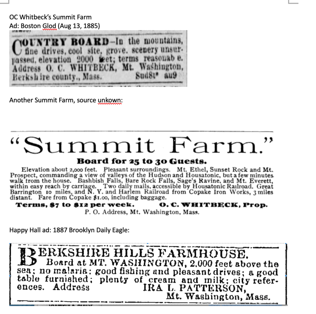
An inn gazed down on the falls from 1879 to 1894, run by the Douglas family who had acquired most of the property extending back towards the Copake Iron Works. On ground across the stream from what’s now the lower parking area, they built a Swiss style chalet with numerous outbuildings, and this became an inn run first by the Vacheron family, and later by a New York City chef named Louis Maquin. But in 1918, this structure burned to the ground, and in the 1920s the land became a car campground.
Ad for early 20th century inn
Notice that in all the examples above, profit is the motive for preservation. The mountains’ beauty is being packaged, advertised, and rented out. That’s not to blame Milo Smith, or even the wealthier ski developers: they needed a way to earn a living, and the result was a healthier ecosystem. But their scenery-based businesses serve as a baseline to measure a certain transformation. By the turn of the century, that subterranean yet powerful force — public sentiment — was changing in ways that had a profound impact on the Taconics.
John Muir must be mentioned as the avatar of this shift. More than anyone, he successfully pioneered and publicized the concept that natural beauty had value in and of itself, never mind commercial worth. In a 1912 letter written as part of his famous struggle to protect the Hetch Hetchy Valley in California, he deplored those who were “eagerly trying to make everything dollarable.” He compared his beloved valley to the Jerusalem temple that Jesus fought to save from the money lenders, and eloquently recorded his core belief: “It is impossible to overestimate the value of wild mountains and mountain temples as places for people to grow in, recreation grounds for soul and body.”
He got the ear, most importantly, of Theodore Roosevelt, but I wonder if his words — or at least his sentiments — reached the ears of influential men in the Taconics. In 1908, Massachusetts established a Mount Everett Reservation Commission, “authorized to take, or acquire by purchase, or gift, land situated in the Mount Everett Mountain Range.” $5,000 was set aside for this purpose. This initiative did not stem primarily from any practical concern (such as fire suppression) but from the desire to protect a mountain whose “…dome dominates the landscape of the South Berksires like a mighty sentinel.” The time had come to save beauty.
But preservation proved no easier then than now; while the Commission quickly bought 400 acres on the north slope of Everett (from OC Whitbeck for $1500) and a nearby 125 acres for $500, it stumbled when it used eminent domain to claim a tract on the west slope that included “Undine Lake.” (Guilder Pond today.). The owner, James McNaughton, sued, claiming he’d been given unfair value, and citing the Whitbeck property as a comparable. But the Judge ruled that no comparison could be made because the worth of the McNaughton land “did not consist so much in the land itself as in its sentimental value … as a sight-seeing place.” So McNaughton had to eat his price. But it’s worth noting that in 1915 a court recognized that land could have a value purely aesthetic.
The efforts of Massachusetts to preserve its mountain lands were aided, around 1898, by the water levels of Berkshire streams.
Why? Because a New York wool merchant named Frederick Masters was an avid fly fisherman. His grandson Edgar describes him as a tie-your-own-flies purist with waders and a wicker basket. But in the spring of ’98, the Massachusetts streams he loved to visit were dry, and someone suggested he go “over the hill” — past the site of today’s Catamount (then known as Molasses Hill) to Copake Falls, where rains had been more consistent. Masters took to the area, had some drinks at the Taconic Wayside Inn, and met local store owner Thomas Keating, who told him of an abandoned farm in a nearby valley known, for some reason, as “Little Europe.” (A local iron worker used to finish his drinks at the Inn with the proclamation: “I’m going to Little Europe,” climb the hill, and sleep there in abandoned barns.) In a horse and buggy, Keating took Masters to view the property; Frederick immediately noticed the steady springs and, envisioning trout ponds, bought the land from the iron works owners (whose furnace was still an immediate neighbor.) By the 1920s he’d built what his grandson describes as a “gentleman’s summer home” constructed of chestnut.
By this time the spirit of Muir had begun to shape the priorities of powerful New Yorkers, including then Governor Al Smith, future Governor Franklin Roosevelt, and Robert Moses, who had established and put under his power a New York State Park Commission. Roosevelt, who grew up in Dutchess County, dreamed of a motorway connecting parks along the east side of the Hudson Valley, like a string threading beads. In 1922, as part of a State Park Plan, a tri-state park was proposed, imagined to contain all the long-admired beauties of the Taconics. (Taconic State Parkway was originally meant to swing closer to the border.) The Plan looked at the Taconics as a “splendid opportunity,” shown plainly if you put together maps and “see the significance of this mountain mass.”It would encompass 20,000 acres in Massachusetts, 11,000 in Connecticut, and 9,000 in New York. Rather bluntly, the Plan described the New York area as “… not of any value in itself but western slopes are needed for fire protection and no one state can do it.” One problem foreseen: “The greater part of public use will come from New York while greater cost of purchase and development falls on Connecticut and Massachusetts.” Neither of New York’s neighbors wanted to appropriate money for use in other states. But in 1925 the State Legislature created the Taconic Park Commission to help move this vision forward. Roosevelt and Masters were members, Roosevelt chair.
The first parcel deeded over to this burgeoning project was 38 acres along North Mountain Road, belonging to Frederick Masters. But the centerpiece of the Tri-State Park vision was the eighty foot Bash Bish torrent. It crashes and spills in Massachusetts, but the only practical access came through New York, past the site of the vanished Swiss chalet / hotel. So Masters bought about 200 acres necessary to save the entire area. He held it in his wife’s name for a few years, and sold it at cost, with a proviso that it be held public forever.
While a formal tri-state park has never been established, the intent has succeeded. Massachusetts steadily put the pieces together, beginning with the 1924 creation of a 424 acre Bash Bish State Park based on Masters’ donation. By 1968, gifts from the Van Der Smissen family allowed for the 4,619 acre Mount Washington State Forest (including the summit of Alander). Jug End Reservation was added in 1994. By the time its original Commission was disbanded in 1975, Mount Everett Reservation had reached 2,492 acres. For its part, New York has added to Taconic State Park until its 5800 acres form a protected strip along the western flank of the mountains.
Entrance to Taconic State Park, 2023
That 1908 Commission saw well beyond the slopes of Everett, believing that “… the possibilities of the territory” were “magnificent in their extensive scope.” Their hopes have been borne out. The 19th century notion that nature owned inherent value — and that government played the key role in preserving it — has held, and grown, through the decades.
But there’s a bit of irony behind this shift in public feeling. One crucial underpinning is, of all things, the invention of the automobile. Raymond Torrey, author of a 1926 study of potential state parks, was clear-eyed on this: he saw that the environmental movement in New York was “accelerated by nationwide conservation influences” but also by the “immense increase in outdoor life due largely to the invention and perfection of the automobile.” Like Robert Moses, he believed that “Highway and park development went together.” At a 1948 meeting of the Taconic State Park Commission, Francis Masters and others noted that: “Forty years and more ago, the rugged hills were more frequented; lovers of nature drove through in weekend jaunts with horse and buggy.” But visits — at mid-century — were down because “automobiles don’t take to rough dirt roads.” So park development meant road paving. Those pioneers can hardly be blamed for lacking a crystal ball, but a century of carbon emissions has not been kind to the mountains they loved.
What use do we make of used-up but lovely land? The story of the Taconics illustrates several answers. One: deploy it for commercial gain, as with boarding houses and ski areas. Two: use government to protect it and open it to all comers.
Three: allow private conservation groups to fill in the gaps left from government purchases. Today, the Appalachian Mountain Club and the Nature Conservancy maintain important pieces of mountain land, and the Appalachian Trail, which leads from Lion’s Head to Jug End, is federally protected.
Four: build summer camps. These are private ventures, of course, but are steered by a public mission. Camp Hi-Rock, established on land around Plantain Pond in 1948, declares its purpose as: “the growth and development of the spirit, minds and bodies of the participants we serve.” The leaders (from the Bridgeport, Connecticut YMCA Chapter) who found the land and built the camp were guided by the faith that a site in the wilderness was ideal, that there was an intrinsic value in introducing young people to nature.
Northrop Camp, which operated for seventy years until a 1993 fire destroyed its main building, is a particularly inspiring story. A New York botany professor, Alice Rich Northrop, decided in the early 1920s that the city schools failed to offer any thorough study of nature or ecology. So she planned to turn her property on East Street in Mount Washington into a summer nature camp for underprivileged city kids. But in 1922, driving upstate to make final preparations for the initial season, her car stalled on railroad tracks. She was hit and killed.
This didn’t stop her friends from opening the camp the next summer, with two groups of twenty boys sleeping in tents, using an old barn for a rec hall, and washing with cold water in an old shed. The next summer’s campers were two groups of girls. Despite — maybe because of — the spartan conditions, the Northrop experience changed many lives. Recollections, from decades later, testify that campers came “to know that there is a beautiful world beyond the concrete caves we call home” or learned that “rain, wind, stars and moon were part of me.” One believed that a “Deep love of nature and creations’ wholeness fostered in three short summers has enlightened me all my life.” They studied plants, met raccoons face to face, and at least once cooked and (tried) to eat rattlesnake. The trail from the Northrop site to Bash Bish falls, blazed by can lids nailed to trees, can still be followed. In recent years, led by alums, the camp has been partially rebuilt and short camping sessions have been revived.
“Tin can” trail from Northrop, 2023
A fifth approach to the “What use?” question can be found in Connecticut. Judge Donald Warner, a prominent citizen of Salisbury, began buying lands around the abandoned Mount Riga furnace in the late 1800s. He’d lend money to colliers who were still working the mountains, enabling them to buy ten or so acres at a time. Once they’d harvested all the useful timber, Warner would buy the land back, and so steadily increased his holdings. In 1896 Warner learned that the local bank held tax liens from the Millerton Iron Company, which at that point owned the old furnace lands. He was able to cheaply purchase about 5,000 acres in Mount Riga. But, moved perhaps in part by the tax burden of so much property, Warner looked for partners. In 1922, three families —the Warners, McCabes and Schwabs, all interconnected by business and marriage —- formed a corporation to control the property. These families already had smaller holdings on which they’d built “camps.” The McCabe version boasted a barn, main cabin, and satellite cabins constructed of chestnut.
This was the basis of Mount Riga Incorporated. It was — unusually at the time — set up as a for-profit land-holding company. Land was controlled by the Corporation, but lease-holds were sold, so houses could change hands. Eventually about 350 people formed a seasonal community, in homes that lacked electricity and in some cases running water.
This remote society was threatened in the 1950s, when the state of Connecticut (finally) decided to help form that Tri-State Park proposed in the 20s. (Apparently the indefatigable Robert Moses had begun to push the idea again.) New York promised to buy 1,000 acres in the Taconics to add to the project. But Salisbury rebelled. Led by State Representative Jack Rand, they lobbied Hartford, arguing in part that it was wasteful to, as one citizen remembered, “spend state money for land way out in the sticks.” At one point, Dan Brazee even brought his pet deer to Hartford and declared that this Tri-State Park idea would deprive Bambi of its home. (Though wouldn’t Bambi be at home in a state park?). In the event, Hartford backed down, though many thought this had less to do with Bambi and more with the tight purse-strings of state government.
This eliminated the threat of a state takeover, but financial problems plagued Mount Riga — until it was rescued by the Appalachian Trail. That famous footpath begins in Georgia, ends in Maine, and along its fifteen mile traverse of the South Taconics climbs up and down Lions Head and Bear Mountain, dips into Sages Ravine, and ascends and descends Race Mountain, Mount Everett and Jug End.
Under the Carter administration, the A.T. came under federal protection: prior to this, much of its route had depended on the goodwill of many different landowners. The Mount Riga Corporation owned most of the trail’s route in the Connecticut part of the Taconics, and the sale of this land to the state raised over a million dollars that enabled the Corporation to, among other things, make repairs to the Riga Lake dam. Corporation member Charles Vail characterized the A.T. sale as a “win-win” that allowed the Mount Riga community to restore and maintain its property.
Oral histories collected by the Salisbury Association preserve fond memories of Mount Riga that reach a hundred years into the past. Gustav Schwab recalled hiking, at night, from Riga Lake to the “western lookout” (now the intersection of the South Taconic Trail and Quarry Hill Trail) where he and his friends watched the trains in the valley below. When they saw steam rise from a locomotive, they’d count the seconds until the noise reached them. Mike McCabe remembers, in the 1940s and 50s, using a pony and cart to collect garbage from fifteen different camps, and feeding it to pigs who were kept on the mountain. Dan Brazee, caretaker in the 1950s, rescued a young deer from dogs and raised it as a pet (the Bambi who eventually lobbied Hartford.)
Today Mount Riga Incorporated is still a private enclave, but anyone can apply for permission to camp there or swim the lake. In the 1980s, the group donated, to the Nature Conservancy, land around Bingham Pond Bog (a haven for rare plant species) and also Bald Peak. In 2008, a deal with the Nature Conservancy allowed the South Taconic Trail to extend to Rudd Pond.
In 2009, in a talk on the history of Mount Riga, summer resident Jim Dresser characterized the appeal of the off-the- grid lifestyle of the camps: “Mount Riga’s current culture tosses a monkey wrench into the engine of so-called progress.” Camp owners “simply refuse to stay on the escalator carrying our society to greater creature comforts.”
Today the railroad, the boarding houses, many of the camps and resorts are vanished. But the Miss Sedgwicks of the world still find the South Taconics, still seek a ready encounter with nature. The internet lets them tell the world what they find, but perhaps the inner experience is as quiet as ever.
(Note: Thanks to Mount Washington Historical Society for research, advice and image sharing)
A riddle: how was the iron industry similar to the spongy moth caterpillars that, as I write, are chewing up the leaves of entire mountainsides? Answer: left unchecked, they both tend to eat themselves out of house and home.
For the iron industry, of course, that meant chopping down forests faster than they can regrow, thus choking off the industry’s fuel supply.
Ironically, around the time John Muir was pioneering a path for the American environmental movement, voices within the iron industry were also speaking out for conservation — not for love of nature, but for the sake of self-preservation. Silliman believed that the “entire consumption” of the “very dense forest” of 1820 “would seem beyond the power of any population which is likely ever to accumulate in these regions.” But an 1880 article in the Journal of the US Association of Charcoal Iron Workers stated plainly: “The large area of woodland which is annually cleared to produce fuel for the various charcoal iron works of the country would indicate that but a few years of existence are still granted to the industry.” Also: “We are really the only trade organization whose interest it is to encourage the growth of the forests.” In many areas, there was a concerted attempt to restrain the clear cutting of woodlands, and fight the fires and over-grazing that also threatened forests. Some tried to use more sawmill scrap for charcoal making. But the industry was always up against the vast and non-stop need for more and more wood; the 1880 article estimates that the industry as a whole consumed 1,120, 000 cords per year.
How did this play out in the Taconics? There may have been very few colliers in the area in 1860, but there were plenty of furnaces. In the second half of the 19th century, blasts burned in Copake, Irondale, Maltby (near present day Rudd Pond), Salisbury, Falls Village — and the Mount Riga furnace was only recently shut down. (For the sake of argument, I’m leaving out the many furnaces that were a little further afield). The obvious conclusion is that most of the valuable wood in the Taconics had already been fed to the furnaces, and owners were reaching out for new sources of fuel.
Some math reinforces this idea. How many acres of wood per year did a typical furnace require? Estimates are only loose guesses because, of course, there really was no “typical” furnace: their size and efficiency varied widely. The Copake furnace required 450,000 bushels of charcoal per year; given that an acre produced about 30 cords of wood, and three cords produced 100 bushels of charcoal, then that furnace clear-cut about 450 acres per year. But let’s take the lowest estimate I’ve found and say the furnaces ringing the mountains required about 330 acres of cut woodland per year. The entire South Taconic range encompasses about 36,000 acres. So one furnace in one year would eat up less than one percent of the South Taconic forest. But there were at least five furnaces on the borders of the woodlands. Five furnaces would burn 1,650 acres per year, or close to five percent. A clear way to imagine the impact is to estimate that the entire 36,000 acres, at this rate, would be cleared in about 22 years.
Another way to consider the impact of charcoaling is to ask: how many charcoal pits were in operation in the 19th century? Edgar Masters, owner of about 800 acres close to the site of the Copake Furnace, has diligently counted and found 154 charcoal pits on his land alone. The Hawthorne Valley Farmscape Ecology program has used LIDAR technology (which utilizes aerial imagery to spot sites fitting the shape and size of charcoal pits) to demonstrate that there once were several hundred just along the New York edge of the mountains. Not all of these were in use at the same time, of course, but the sheer numbers speak to a powerful impact on the landscape.
Mount Everett, from Picturesque Berkshire, 1893
All this speculation immediately invites more speculation. Did those five furnaces exclusively use wood from the Taconics? Doubtful. But, conversely, did some of the other furnaces in the region also draw charcoal from the tri-state mountains?
Forest, of course, didn’t cover all the mountain land to begin with: in 1850, with Mount Washington’s population near its peak, farmers held 2,730 acres of “improved” land, and 5,554 “unimproved” acres. “Unimproved” land meant it was “used for farm purposes other than growing crops.” So something like 7,000 acres of mountain land might have been deforested with no help from colliers.
Also: iron furnaces were not the only hungry industries in the mountains. By 1820, there were sawmills along Bash Bish creek, on the Wright farm, and one near Sky Farm. An 1858 map of Mount Washington shows three sawmills still in operation. A tannery along Huckleberry Brook might have had an outsized impact on the forest: hemlocks didn’t make good charcoal, but were precisely the sort of wood needed for tanning leather.
All these layers of evidence help to clarify the picture I most want to see: what did the mountains look like in, say, 1900? Ernest Rebillard told his children that by the end of his collier days the mountains had been “stripped.” But this may have been an exaggeration. Consider, for one thing, that clear-cuts don’t stay clear-cut; forest immediately begins to regenerate, especially from species that can stump-sprout. Within thirty years or so, a woodlot might contain trees large enough to cut again. Hemlocks, spared the ax by colliers, bear evidence of this pattern. Foresters have examined tree ring patterns that show heftier growth roughly every thirty-five years — suggesting that the hemlocks’ competition had been decimated every three decades or so.
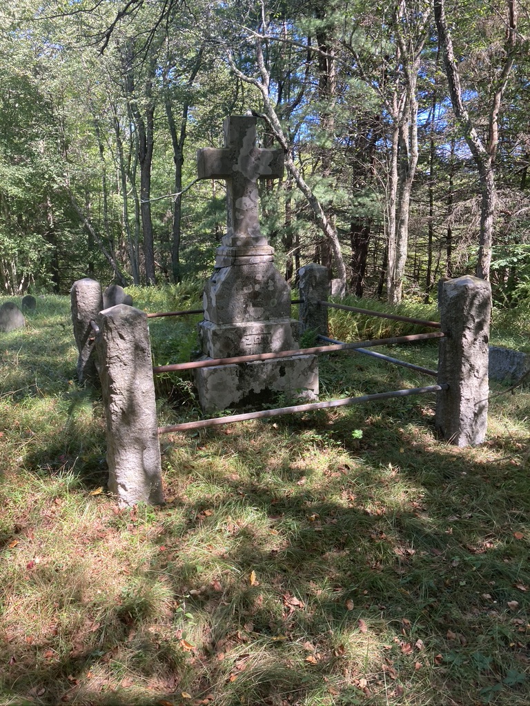
There are several old images that bear this out. For quite a while, I puzzled over a turn of the century painting of the tri-state boundary marker near Mount Frissel. Why did the monument seem to rise in an open field? Oh! I finally realized — the mountainside was a scrubby field at that time. A circa 1890 photograph of the old Dutch cemetery from Picturesque Berkshire shows a vista of open ground and patches of forest. A view from around that time, looking west from Mount Riga, seems to show unbroken forest.
Tri-state marker, c. 1900Tri-state marker, 2023Old Dutch Cemetery, from Picturesque Berkshire, 1893Old Dutch Cemetery, 2022Bald Peak, looking west towards Riga Lake, 1893
The Book of Berkshire contains several detailed descriptions of the Taconics landscape, circa 1871. This volume seems written with an eye towards growing the young tourist industry of that era, so perhaps its images skew towards the pretty. But while the Reverend Powell rhapsodized over the area’s autumn foliage, he also carefully recorded the tree species of his day: hemlock, sumac, hard and soft maple, oak, beech, sugar maple, birch, and chestnut. “The sidehills,” he tells us, “were masses of gold.” Mrs. Goodale, of Sky Farm in Mount Washington, tells of: “Green fields, cattle on hills, scattered farmhouses, broad stretches of woodland, occasionally laid low by the woodchopper’s ax, plumed by the soft wavering column of the charcoal pit but oftener answering only to rhythmic fingers of the wind and echoing no harsher sounds than the cooing of the wood-dove or the persistent plaint of the whip-poor-whill.” A boarder at Alander House (which stood near where the Massachusetts State Forest Headquarters stands today) saw “From all my windows the grandest and loveliest scenery …. Within a few minutes’ walk over a notch in Ashley Hill I could be in the great lonely wilderness stretching away west and north to Alander Mountain which was fairly palpitating with vivid color.”
It seems clear from such eyewitness accounts that all those swinging axes had failed to erase the forest. Here, a working pasture. There, a field going back to juniper and pines. Over there, acres of stumps. That way, intact forest. This must have been the landscape left by the industrial age.
Around 1900: farm, field, forest
Each clear-cut would have undergone a predictable succession, similar to patterns seen today. Those adolescent forests of the 19th century, with their pine, birch and aspen, might still seem somewhat familiar to us — with one crucial exception. Because it sprouts so readily from stumps, chestnut would (after the initial cutting) have dominated 19th century woodlands. Some guesses are that 80% of the post clear-cut growth might have been chestnut. But this exceptional tree, renowned for its tasty nuts and straight-grained wood, enjoyed only a short dominion. 1915 saw the arrival of the chestnut blight, which swiftly decimated the species, leaving behind only the stubborn shoots scattered throughout today’s woodlands. Edgar Masters remembers, from his childhood in the 1940s, a forest filled with dead chestnuts which made excellent lumber and firewood. The same forest today is dominated by red oak.
Mount Everett summit, 2023
The assault on the forest may have begun to slow not long after the Civil War; the lack of colliers in the 1860 census certainly hints at this. Local forester George Kiefer estimated that most cutting ceased about 1885. An article in the Journal of the United States Association of Charcoal Iron Workers, from that year, states that the Copake furnace was getting most of its wood from Vermont, and the Irondale furnace in Millerton depended on sources “west of the Hudson.” It seems that by then, the local iron industry was on a steady slope towards oblivion. The tone of an 1884 article (in the C.I.W.A. Journal) indicates that the iron district “[o]n the eastern slope of Tocconuc [sic] range of hills” was already seen as a quaint backwater: “Few realize … there are still in existence nineteen charcoal blast furnaces near Salisbury.” (The writer did appreciate the landscape: “The general topographic features are most attractive and nature has generally provided picturesque surroundings for the mines and blast furnaces.”)
Destruction of the forest was not the only reason for this decline. Competition from furnaces in Pennsylvania and the South (where labor was cheaper) cut into profit margins. The high quality local ore became less valuable as new technology allowed furnaces to process lower grade ore. Even more important: a Lakeville man led the way towards new techniques that left the major industry of his hometown obsolete.
Alexander Holley was the great-grandson of Luther Holley, one of the original backers of the Mount Riga furnace. After an early career in the railroad industry, Holley traveled to England in 1862 and met Henry Bessemer, a pioneer in forging steel. He brought this technology home, and by 1880 nationwide production had grown to 1.2 million tons. The rise of steel, sturdier and more resistant, meant the demise of iron.
There were many practical reasons no steel industry took root in the Taconics region, lack of water volume being first. But according to one story, when Holley was asked; “Why not bring steel to your hometown?” the answer was: “Because I love Salisbury so much.” It’s hard for present day residents not to be glad that we were spared more years of industrial flame and noise, of chopping and felling and charring. The decline of the furnaces meant the rise of the forests. Today, it’s hard to imagine the mountains without their verdant covering, but only a few generations separate us from that landscape of stumps and brush and tall trees.
In considering the massive footprint of industry on the Taconics, it’s easy to overlook the places left untouched. There are a few. If you’re wondering why some trees escaped the ax, try hiking along the south side of the Bash Bish gorge—but bring your walking poles! The slope is so precipitous, it’s easy to imagine woodchoppers taking one peek and walking away. Today, that side of the gorge is covered with a dank forest of old growth hemlock.
Or, if you don’t mind thrashing through dense mountain laurel, explore the flanks of Mount Everett or Undine. A 2002 survey estimated there are 350 acres in this area dominated by trees 175-300 years old (a few even older) and another 500-600 acres containing trees 150 years old or more. Again, these forests rise on terrain made remote by steep slopes and narrow ravines.
Pitch pine and gnarled oak, Mount Everett
I used to imagine that “virgin” forests might be found only in the West, or perhaps remote corners of the southern Appalachians, in forgotten pockets containing massive and towering trees. But the old growth in the Taconics is remarkable for its diminutive size. Diameters of 14-28 inches are typical, and one observer describes an “elfin forest of bizarre shapes.” These gnarled hemlocks, red oaks, black birches, red maples and white pines root into scant soil atop highly resistant schist, and must survive winter’s winds and brutal ice storms. They grow, but slowly. Some of the hemlocks here may be 400 years old.
Atop Race, Bear, Undine, Everett, and nearby Hill 1914 (named for a summit monument bearing that number), an even more stunted and odd forest grows. Shrub-sized pitch pines and bear oak live up there essentially because nothing else can. The soil is even thinner, the winter storms worse. The result is rarities: pitch pine is found in the northeast only in coastal Maine, the Shawangunks, and the Taconics. (I’ve also found a few scattered pitch pines atop Cedar Mountain and along the Paradise Lane Trail.) A 2009 study by Harvard Forest argued against the common notion that frequent fires allow the pitch pines to spread here; their presence is instead explained by the severity of the environment. But survive they do: Hill 1914 boasts a 241 year old pitch pine, the oldest ever found in Massachusetts. The average age of these trees was estimated at 111. The Harvard Forest researchers called it an area “worthy of the most stringent conservation measures.”
But here’s another oddity: walk along the west side of Guilder Pond, just below Everett, and you’re strolling through … another old growth forest? Core samples taken here have shown that some of the hemlocks are 250 to 300 years old. This is not a remote and inaccessible spot; why were these trees left to stand? Maybe no-one ever bothered? Maybe the owner refused to allow cutting? It’s easy to pigeonhole our forebears as unable to see anything in a tree but money. But Judge Donald Warner of Salisbury, reminiscing about his mid-nineteenth century boyhood, recorded of his Great Uncle James: “I could not help observing as I tramped through the woods with my uncle the great love amounting almost to reverence he had for the growing and thrifty stands he had watched from his boyhood – a love which would not permit him to apply the axe to any but decaying or fallen trees from the needs of the farm.” (It must be noted, though, that once Uncle James was dead, this forest was felled as part of the estate division.).
Old growth hemlock by Guilder Pond
If you view the history of the Taconics ecosystem from a 21st century perspective, the 19th looks like an interruption. Before this era, forest-covered mountains held a wilderness full of wildlife; after—forest-covered mountains held a wilderness full of wildlife. Of course, in all sorts of ways it’s not the same ecosystem. Where are the chestnuts? The elk? The wolves? How about the ash trees, which are steadily falling victim to invasive pests? How about the arrival of the wooly adelgid, a mortal threat to those ancient hemlocks?
But the 20th century was kind to the mountains in many ways. Land stripped and eroded by woodchoppers and sheep grew protective coverings of shrubs and trees. Animals driven out by industry returned and many newcomers (such as coyotes) arrived. The human population shrank, and the human impact diminished—at least at the local level. (Global level impacts such as climate change are another story.)
But the mountains are still used by people, just in very different ways. Once a place for work, they’re now a place for relaxation. Once a center of industry, they’re now a place for retreat from the modern world. But the beginnings of the tourist and second home transformation can be found in the midst of that past era of smoke and noise.
Every fire needs fuel, but ore-melting fires required a particular fuel: charcoal. On my desk I keep several examples that I’ve found in the Taconics, black, almost weightless little chunks.
This charcoal is a kind of condensed lumber. By intensely heating it while using as little oxygen as possible, all moisture is removed, and the resulting fuel is lighter, gives off little smoke, and burns hotter. It was the ideal fuel for blast furnaces. But transforming trees into charcoal is a dirty, artful, demanding, lonely, and sometimes dangerous task. By the 1880s, the fuel was often made in tall, red-brick kilns near furnaces, but for most of the century, the charring took place on isolated mountainsides. If you were a 19th century collier, here’s how you’d go about it.
Begin, of course, by cutting down trees. Tools: axes and saws. It’s a winter job — cold keeps sap in the roots, leaving less pitch to burn off, and snow allows use of a sleigh. So you, the collier, might do all your own cutting, or might buy some cords from an off-season farmer. (Early on most choppers were the owners of the woodland.) You need about thirty cords for each round of charring, but this varied according to the size of the “charcoal pit,” the type of wood, and the weather. The Journal of the US Association of Charcoal Iron Workers in 1880 described the “wood chopper with his cord tally kept on a piece of sapling.” A good chopper could produce three cords a day, green wood only. Hardwoods were best, but any type of tree would do, except hemlock, which no doubt contributes to its prevalence in today’s forest. Trim off small branches; four foot logs are needed. If you’re a chopper selling to furnaces or to colliers, expect about 25 cents per four by eight foot cord. If you’re a man without honor — or maybe just desperate for a quarter? — you might try to sell a short cord, by setting the wood in hard to measure rows, cutting logs a little short, stacking on a hidden stump or stone.
Once you’ve got sufficient wood, build your “charcoal pit” — which, by the way, is not a pit at all (unclear where that term arose, but it may be that long-ago Europeans used pits).
Charcoal “pit” in progress
First: choose a spot a reasonable distance from the furnace you plan to sell to, but also close enough to timber supplies. Clear a flat circular area, about thirty feet in diameter, digging out mountainsides and levelling with fill where needed. This might require moving quite a bit of dirt, hauled in wheelbarrows whose wheels boasted a four foot diameter to cope with the rough ground. These charcoal pits dot the Taconics in great numbers today and are still pretty easy to detect if you know what to look for: flat circles in the woods, of the above-mentioned diameter. They resemble long-forgotten putting greens, and because of the intense burning inflicted on them, are still often free of much vegetation, except perhaps aspens. Dig along the edges, and you can find pieces of charcoal, left behind for a hundred some years.
Second: build a “chimney,” a mound of chopped wood, about ten feet tall. (There’s a recreated example near the Copake Iron Works.) Begin with a kind of teepee of logs; lean another layer against this, and again until you reach the edge of your flat circle. You’ll need an opening at the top, in which to insert a pole to mark the center and also help you gauge how far charring has progressed. (You can pull it out and re-insert as needed.)
Third: Stack “billets” — hardwood logs or boards — all around your mound. Be careful to plug as many gaps as possible with dirt, leaves, or scrap wood.
Fourth: “Leaf the pit.” Scatter leaves or straw over the billets.
Fifth: Add layers of dirt over the leaves, again with an eye to seal the mound as much as possible.
Sixth: Use a notched board to climb atop the mound and clear dirt and boards from the opening. Drop in coals — “fire the pit” — and replace the dirt and boards.
Seventh: By now you’ve probably worked a very long day or two, and you might get some sleep. But the mound must be checked overnight! You want an “earthy” odor. If the smoke smells like a campfire, too much oxygen might be getting inside. Plug any holes with dirt. Beware of contact between the heated charcoal and fresh air: potential explosion. Beware of air pockets forming. You might have to “jump the pit” — climb atop and leap up and down to jam the mass tighter. Don’t think about what might happen if you’ve failed to build a firm mound. If one side of the pit isn’t charring enough, open a hole to draw oxygen that way. This might blast you with smoke and you might look (according to one observer) “black as the devil.” If blue smoke is escaping, be satisfied. Dark smoke means some part is not charring, but burning up!
Eighth: By now you’ve been at this for about three days with little sleep. But the upper part of your mound is probably starting to contain good charcoal. Keep watch, through a fourth …. fifth …. sixth … seventh … eighth … day.
Most of the smoke should be down by now. Maintain your vigil through day nine ….
Next day — harvest — although, depending on type of wood, size of pile, and weather, your “burn” could take a full two weeks. Open the mound and rake the charcoal out towards the edges of your circle. Keep water handy in case a blaze breaks out.
Then haul your product to market — whatever furnace is nearest and paying best — in a specially designed wagon with a broad bed and sides sloping outwards. Make sure your charcoal is entirely cooled! There’s one story of a cart on its way down a mountainside that suddenly burst into flames and, unhitched, sped on like a blazing meteor until it crashed.
A load of charcoal about to be carted away
Oh, and, by the way — any good collier and his crew maintains several pits at once, trudging from one spot to the next to make sure all is charring well.
Maintain this work pace through spring, summer and fall. Live in a log hut; subsist on salt pork, potatoes, beans, bread, onions, and likely much liquor. (Gum opium was also apparently common with colliers.) Don’t expect to see friends or family except on the occasional Sunday. Don’t expect much respect for your trade, however skilled it might be. One daughter of a collier recalled: “This occupation was considered a lowly one by the boiled shirt citizens.”
Yet you could have visitors, curious souls who might request a charcoal chunk to drop down a well and “sweeten the water.” Or healthy-minded folks might want to stand downwind of the supposedly “purifying” smoke.
Charcoal pit — “fired”
All this begs the question: who would want to do this job? And why?
One simple answer to the “why” might be — pay. Uneducated, landless workers in a rural area like the Taconics didn’t have a host of choices when it came to earning a living. Farm labor? Furnace labor? Each burn usually produced over 1,000 bushels of charcoal. Industry records show that in 1884 the various furnaces paid around eight cents per bushel of charcoal. That would mean each burn was worth roughly $80 to the collier. Granted, this was seasonal work, and the time needed per burn could stretch up to two weeks; don’t forget site preparation and hauling. Also, you might need to pay a wood chopper if you didn’t do the cutting yourself. But a skillful collier could doubtless handle more than one burn at a time. Couldn’t they do better than the $105 per month even the best paid furnace workers earned?
Skilled workers who may have drawn decent pay, colliers still lived on the margins of society. So it’s hard to be certain what part of the population worked the charcoal mounds. Some may have been immigrants who moved from one area to another and left little trace in written records. The prevailing opinion, in the secondary sources, is that European colliers migrated to America to practice their trade here — Frenchmen, Germans, men from the Baltic states, Scottish indentured servants, even Schagticoke Indians. (There’s apparently some evidence that Jacob Konkapot, a leader of the Stockbridge band, delivered charcoal.) The Journal of Charcoal Iron Workers in 1884 mentioned that one Connecticut furnace employed “mostly French” colliers.
But there’s evidence that many colliers were simply local people who worked the charcoal pits for a time, and moved on. An 1850 “Products of Industry” census for Mount Washington lists seven men with familiar local names like Spross, Wright, and Race who ran charcoal businesses, each employing several more men. A total of 26 workers produced, in that year, 84,200 bushels of charcoal, worth $5724.
Charcoal “pit” above Copake Iron Works, 2022 — the enbankment in the background is a clue
Census records suggest that collier was a temporary status for many. J. Shook from Ancram in 1850 worked as a collier, but in 1860 as a laborer, and in 1875 and 1880 in a paper mill. Salisbury resident Hiram Sardam, a collier in 1850, was a basket maker in 1860. A decade after “coaling,” Samuel Fields had moved from Mount Washington to Dalton and become a teamster. Christian Winters left charcoaling behind and farmed in Chenango County. Several Mount Washington residents were listed in the 1850 census as “farmer,” while, in the same year, the Products of Industry document has them making charcoal.
A search through the 1850 census for Copake, Ancram, Salisbury, Sheffield, and Mount Washington yields thirty-eight names working as colliers or “coalers.” Salisbury had more colliers than any other town, but only one was foreign born, an Irishman.
So the truism that most colliers were immigrants seems a bit of a myth. Instead, it may have been an occupation that young men from local families worked at until they could move on to something—more respectable? Cleaner?
But I met with the granddaughter of one of the last of the Taconics colliers, Lynne Reifsnyder of Salisbury. She explained that Ernest Rebillard emigrated from a French village called Cheve Bier, and after a time in Buffalo and a return to France, settled in Mount Washington as a collier. He was only one of many emigrants from the same village who made this area their home. He lived with his family on the mountain, in a cabin where his daughter was born in 1889. By the turn of the century, with the iron industry failing, he moved to the Salisbury area and found other work. But Lynne remembers her father taking his children and grandchildren for a walk near Bear Mountain on his eightieth birthday, and pointing out spots where his father had once made charcoal.
A riddle: how was the iron industry similar to the spongy moth caterpillars that, as I write, are chewing up the leaves of entire mountainsides? Answer: left unchecked, they both tend to eat themselves out of house and home. For the iron industry, of course, that meant chopping down forests faster than they can regrow, thus choking off the industry’s fuel supply.
Charcoal, a hundred-some years old, dug out of old Taconic “pits”
Could a woodchuck be responsible for the most transformative event in the history of the South Taconics? There’s a story that surveyors laying out the town of Salisbury in 1728 noticed bits of iron in the diggings around a woodchuck hole. If that critter hadn’t opened a hole there, then, could the entire history of the mountains …
No. No chance the iron veins running through these mountains could have gone undiscovered. Those early surveyors were likely looking for it. In 1686 Robert Livingston extended his manor holdings into a “spur’ thrust into Connecticut land. Why claim land whose title, predictably, sparked a struggle? A good guess is that even in the 17th century, a notion was abroad that the Taconics might contain extensive iron. (Iron rust is visible in some of the schist that forms the base of the mountains.)
Iron, of course, has always been a raw material that industrial civilization depends on. For early Americans, everything from nails to horseshoes to plows to weapons was iron made. But it wasn’t practical to ship great amounts of heavy iron objects from Europe to the New World, so the search for ore began almost as soon as settlement.
What those Salisbury surveyors stumbled on wasn’t just any common sort of iron, however. High in manganese, low in phosphorus, Taconics iron was peculiarly strong — someone at the Smithsonian even described it as “perhaps unexcelled in the world.” Its durability under repeated shock allowed cannons, high grade plows, ship anchors, and locomotive wheels to be fashioned from it. Those flecks found by that woodchuck hole led, in time, to forty blast furnaces within reach of the mountains, a thriving town built on the crest of the mountains (Mount Riga). an industry-fueled population boom, and the steady depletion of the Taconics forest.
In the 21st century the deafening, hammering noise, around the clock flames and smoke, worker villages, open pit mines, railroad sidings and towering stone stacks have vanished. I love to swim in the “ore pit” in Copake Falls, but without the name (and a historical marker) I might not realize that for over a century this deep spring-fed swimming hole once was an ever-widening opening in the earth, swarmed by miners. To the south lies Weed Mines Pond, where forgotten machinery can be found if you’re willing to thrash through some brush. South of this, by Belgo Road, lies another deep water-filled ore pit, and the ruins of a blast furnace concealed by sumac and blackberry. Traces of iron are everywhere — maybe modern day woodchucks still dig up bits.
Remains of Weed Mine operations — built 1870s?Copake Iron Works — late 19th century
At first the iron was worked in forges. One 1731 source describes the ore from Ore Hill in Lakeville “carried in leather bags to Ousatonic [sic], MA to be worked in forges.” But the Livingstons had an Ancram furnace in blast (producing pig iron) by 1743. By 1762 a furnace in Lakeville (then known as Furnace Village) produced two and a half tons of iron every 24 hours. This operation was partially owned by Ethan Allen, of Revolutionary War fame, and became so important to the rebel cause that a Council of Safety took over management, making sure a steady supply of cannons and guns was churned out. A furnace opened in Lenox in 1780, and the unique Mount Riga furnace began operations in 1810.
In 1820 an engineer named Benjamin Silliman travelled through northwest Connecticut and left behind a vivid description of the industry he found. Ore Hill (probably the area’s largest and oldest mine) had been worked for seventy years at the time, but there was “no indication of the ore being exhausted.” It resembled a stone quarry, open to the sky, without shafts or galleries, with “carts and wagons driven freely in and out.” (By 1904, when its useful life ended, underground shafts had reached 247 feet below the surface. Today it’s a very deep pond surrounded by homes.) At Falls Village, Silliman saw a “vast bellows, rising and falling alternately to the action of the water” which “threw in torrents of air, at the bottom, while at top, the workmen were almost constantly occupied by putting in the ore, with charcoal and limestone in successive layers.”
Silliman watched the demanding, dirty, and ferociously hot process of ridding iron oxide of its impurities, and producing usable iron. A blast furnace looked like an enormous stone chimney with a vast fireplace opening at the base. The iron ore, charcoal, and limestone dumped into the top of the chimney met a blaze, bolstered by pumped air, near the bottom. Oxygen is the number one impurity, so, in temperatures reaching up to 3,000 degrees Fahrenheit, the oxygen in the ore combines with carbon monoxide in the fuel, and is expelled as CO2. The height—typically around sixty feet—of the stone stack allowed more time to entirely melt the ore. The limestone combined with other impurities and drew them off. What flowed out through runnels at the base was — once guttermen had skimmed off the slag — iron, pure as it could be made. Connecticut resident Fred Hull remembered a furnace from his childhood: “When the iron flowed out it was white hot, almost terrifying to me. It was dazzling, just like looking at the sun.”
Around the clock, for most of the year, the furnace roared and blazed. Every half hour, into the top of the furnace, workers dumped four to five hundred pounds of ore, thirty to forty pounds of limestone, and fifteen bushels of charcoal. With no gauge, it was up to the iron master to judge whether the temperature and mix of ingredients was proper. Twice a day the molten iron would be “tapped off,” flowing into a channel in sand, and then into side channels at right angles to the main. These side channels reminded someone of suckling piglets, hence “pig iron.” Poisonous gases were drawn off through a vent, where they burned in the air, according to one observer “like a mystical oriflamme…serving at night like a beacon, lighting up the countryside.”
Copake Iron Works 2022
Imagine the workers, usually immigrants, watching over these rivulets of molten metal, directing them with long poles, doubtless praying that their feet wouldn’t slip. Imagine the intense heat, potential explosions (too much water in the mixture?) dust and carbon monoxide from the smelting. Inside the casting house, where the iron was shaped into “pigs”, temperatures could hit 140 degrees in the summer. Backs were strained and injured from lifting the heavy iron pigs. What if the flow of molten material slowed or got stuck? Would you want to be the one who had to poke it from above? Heavy use of beer, rum, brandy and cider helped make this life more tolerable. Often, a barrel of beer with a dipper waited near the furnace. Pay? In the 1860s, supervisors and skilled workers in Copake Falls made $1.50 to $1.65 for a ten hour day. Laborers might earn $1.00 – $1.25 for their ten hours. In an era when flour was about four cents a pound, and a company house might rent for $3.00 a month, these seem respectable wages. Perhaps the working conditions explain why many of the workers were refugees from the Irish famine.
Iron pigs, Copake Iron Works museum
The waste, or slag, was oddly pretty. Silliman thought it showed “often very gay and beautiful colors” and wondered that it had “the strangest resemblance to the glass produced in volcanoes.” When they were small, my children gathered bright blue slag from Bash Bish brook, where it washes down from a long-closed furnace dump.
Iron slag, collected from Bash Bish Creek.
Company towns grew up around the furnaces. Franklin Ellis’ History of Columbia County, New York states that in 1845, just before the establishment of the Copake Iron Works, there was “not a dwelling house” in Copake Falls, and “two old shanties were the only buildings.” But “now” —- in 1878 — the town held forty dwellings, two stores, one hotel, a train depot, two churches, and two hundred people. A railroad 3/4 of a mile long connected the works to the depot; another train brought ore across Bash Bish Creek from the nearby pit. Each year the furnace consumed 8,000 tons of ore, 1200 tons of limestone, and 450,000 bushels of charcoal. Each year, it produced 3,750 tons of iron.
Maybe the most remarkable of all the furnaces around the Taconic mountains was the one built on top. Mount Riga furnace operated for thirty seven years and produced everything from iron cauldrons to ship anchors, but sparks the question: why there? Why build an elaborate blast furnace a thousand feet above and five miles away from the nearest sources of ore and limestone?
Restored Mt Riga furnace 2020
The answer is that ore and limestone were only two of the necessary ingredients for iron production; just as important are timber and water power, and Riga offered the abundant Taconic forests, as well as a steady flow from South Pond.
A forge was built at the pond outlet in 1781. An 1801 attempt at a furnace went bankrupt a year later. But in 1810, Joseph and Seneca Pettee, along with Luther Holley, put a successful operation into blast. Ore was hauled up from Ore Hill by pack horses; limestone from quarries to the east. When the furnace was rebuilt in 1845, the mountain boasted a thirty foot tall stack and a bosh with a sixteen foot diameter. Water rushing over the South Pond dam powered a water wheel and bellows and, downstream, two forges, one making tools such as hinges and kitchen ware, the other turning out cauldrons, plows, even ship anchors. The story goes that the anchor for the USS Constitution was fashioned at Mount Riga. It weighed twenty tons, was dropped from a hundred foot tower to test its strength, and had to be hauled off the mountain into Copake by a dozen oxen.
At its peak, Mount Riga was a village of 700-1000 citizens. They grew wheat, flax, rye, potatoes, and garden vegetables around their homes, and supported a school that in 1821 had 71 students. (It was also the school at the highest elevation in Connecticut.) The largest department store in northwest Connecticut had a $150,000 inventory and four clerks. It enticed ladies to travel up from Salisbury to shop for items including silk dresses. Luminaries such as Governor Morris and John Jay were visitors to the furnace on the mountain.
In 1847 molten metal was mistakenly allowed to cool inside the stack and “froze,” creating a blockage known as a salamander. At this point the mountains were already getting logged out. The school closed when the teacher and students came down with measles, never to reopen.
By 1890 the village had entirely vanished, leaving behind only a few “raggies” who scratched out a living with small farms and lumbering. But a Mrs. Thurston, interviewed in the early 1900s, could remember looking out her window as a girl and seeing “two hundred men on their way to work.”
Maybe I’ve watched too many time-travel films, but I day dream about visiting past times, just to discover how that world looked— or smelled — or just felt. Written records, images, landmarks: these are our only conveyances to the distant past. But they do provide some answers, or at least ground our imaginations.
The federal government, desperate for tax revenue, in 1784 conducted a thorough valuation of the possessions of every American family. The minutes of Mount Washington town meetings begin in 1796 and have mostly survived the centuries. Agricultural censuses date back to 1850.
Another valuable source of info about early farm life in the South Taconics I discovered through a kind of fishing expedition. Herbert Keith, a Mount Washington landowner, in 1915 published a history of the town — valuable, but slim. Yet when I tracked down his papers and notes, at the Berkshire Historical Society, I discovered genealogies of every early inhabitant, stories about them, detailed summaries of schools, Post Offices, Town Meetings. Keith apparently travelled to Boston and hand-copied fifty-some pages of correspondence between the General Court and early settlers. Digging through the pages and pages of notes (all in crisp cursive) left me feeling I’d met a kindred spirit. How satisfying to, in a sense, pick up where he left off over a hundred years ago, and put his work to use.
All these, along with general accounts of American daily life, allow a plausibly detailed answer to what I might have found if I could walk back down the years to, say, 1784 or so.
In that year one hundred seventy seven white people lived in Mount Washington — and zero “blacks.” (But the comparatively wealthy Johannes Spoor, a few miles away, owned two “Negro wenches” and a “mulatto man named Joseph to be free at twenty five years of age.”).
Mount Washington in 1784 had:
39 acres of “field meadow”
84 acres of “English and upland mowing” (this refers to imported varieties of grass).
150 acres of “tillable land”
161 acres of “pasturage”
578 acres of “other unimproved land”
1, 191 acres of “unimproveable land”
My walk back landed me on a mud road, studded with stumps. Let’s say it was summer. A battered log house rose a few yards away, with no other buildings in sight. Children spilled out of the house, most of them wearing gowns of rough linen: one kid, then two, three, four. Pigs slept in the trampled, muddy yard amidst wood chips, boards, and grass tufts. A few dusty windows allowed light into the house. In the yard, a woman kneaded clothes, up to her elbows in steaming water. Below a window rose a pile of trash. The air smelled like smoke and manure. In the distance, as if they moved to a common tune, a row of men swung scythes: snick snick snick, The sweet odor of fresh hay reached my nose.
I walked on. A ram crossed the road, then a herd of grunting hogs. Two men approached, moving heavily and slowly, swinging muscular arms and swaying side to side. They spoke to me with nasally accents, vaguely British to my ears. After looking me up and down, they bowed. Their shirts were stiff with dirt and sweat and stained brown with tobacco juice.
At their invite, I followed them into another log house. A “baby napkin” (diaper) dried by the fireplace. A little girl stared at me for a moment, then curtsied. Imitating the men, I washed my neck and forearms in a bucket of cold water. Not wanting to seem impolite, I accepted their offer of chew, and followed them in spitting a stream of juice towards the greasy floor. A cup of cider followed, which made my head start to swim.
18th century farm kitchen
The light falling through the one window near me was dim and full of dust. In the corner, a woman in a long skirt hacked at stretched-out flax fibers with a swingling knife. Small cuts dotted her hands, but long sleeves concealed her forearms. Nearby, a butter churn rose and fell under the reach of a younger woman.
The men and I chatted about local issues, such as the difficulty in attracting a minister to town, until they fell into a loud dispute about the ownership of a particular free-ranging boar who had broken a recently built fence. I tried to excuse myself, but the men insisted I share a meal with them. From a spot near the hearth, one man lifted a bowl filled with a dense, sand-colored liquid, onto a table consisting of four legs supporting a half-log. The other handed me a spoon, and we took turns ladling corn mush into our mouths. My thirst was quenched by a sip from the shared water bottle.
I thanked them for dinner, and followed the road outside as it gradually became a footpath. Off to the side of the road, a framed house rose — one story, only about twenty feet wide. A little girl in a smock sat on a stump, studying my every move.
In less than a mile, the footpath faded until I had to shove aside laurel branches to make my way. I sat, and the hemlocks and red oaks let me feel I’d returned to my century. But in the near distance, seated atop a broad stump, a wolf watched.
Back at my desk, in the 21st century, I can attempt a larger perspective. First of all: when was mountain land first cleared for crops and pastures? Simple question, vexing answers.
1690, is an answer that other local historians have offered. This is based on the Bull Petition, a document that helped begin the boundary wars of the 18th century, in which unhappy tenants of Robert Livingston’s estate tried to convince the Massachusetts government to annex their land, and free them of the burden of Livingston’s rents. The farmers signing the petition resided on a tract that began “at the top of the first great mountain west of Sheffield in line between this province (NY) and Connecticut, from thence running west in said line five miles and three quarters to the east line of (Livingston) Manor, thence northerly as line of said Manor runs, about eight miles to the south end of a hill called Verdrebick Berg, thence east four miles and a half, thence southerly to the first bounds.” Without trying to guess where “Verdrebick Berg” was, it sounds like this land corresponds — roughly — to the South Taconics. A census lists the year of settlement of each individual farm, and the first recorded dates are in 1690. So the first farms in the Taconic were established in that year. No?
Maybe not. In subsequent missives relating to the battle with Livingston, this tract is referred to as “Tachgkanic.” “Taghkanic” is also labelled clearly on a 1714 map of Livingston Manor, as a cleared area between Roeliff Jansen Creek, and neatly delineated mountains. Also, consider what Ov. Partridge, a surveyor assigned to assess these lands, had to say:
“They (the lands) lie on a small river or brook which heads in Taucaunuck Mountain Runs northerly and southerly some miles the most valuable lands are in the possession of some twenty families more than half the lands mentioned in said petition are upon the great Taucaunuck Mountain which is very high and impassible many miles together the other lands except what are under improvements as above are chiefly white oak rock oak hills some of them pretty good other of them are mean and poor.”
So Partridge makes it clear that only half of Taghkanic lay in the mountains. Common sense suggests that the valley half would be farmed first: why venture into those “high and impassible” mountains unless the better land was already taken? So yes, Henry Brasee, Christopher Brasee, John Hallenbeck, and Abraham and Richard Spoor had all “cultivated” the land there starting around 1690, but they were likely farming in the area that’s now Copake village. (Spoor is buried in the Copake cemetery beside my house.) Many of the names listed on the petition had only been tilling their soil for one to three years; were these families settling the mountain valley where East Street and West Street now run?
Also: the 1751 Bull Petition records that “Taghkanic” farmers were cultivating a total of 772 acres. The 1784 tax valuation document records only 434 acres of cultivated land. The obvious explanation for this disparity: much of the acreage tallied in the Bull petition was not in Mount Washington, not in the mountains at all.
And: Herbert Keith believed the first settlers arrived in 1690. But in his own detailed genealogies, the earliest farm dates only to 1735.
That’s a lot of explanation for a straightforward guess: farmers did not settle the Taconics until the first half of the eighteenth century. Keith believed that by 1757 there were about 200 settlers in the Taconics. By 1800, the census shows 291. The height of population was reached in 1840: 438.
How did they earn a living, once the land was occupied?
There are no direct records of crops grown, until the 1850 Federal Agricultural Census. But it seems fair to assume — given some other “sideways” evidence — that the 1850 numbers reflect longstanding practices.
In 1850, mountain farmers grew a lot of potatoes (“Irish” potatoes, not sweet.) 5,248 pounds, to be exact, grown by 28 listed farmers. (Later in the century, the Goodale family originated several kinds of potatoes, and got a yield of 300-700 pounds per acre.) They also grew quite a bit of “Indian corn” and oats. Those oats must have helped feed the cows, who produced 6,603 pounds of butter and 5,011 pounds of cheese.
Zero bushels of wheat grew in the mountains that year, and only 581 bushels of buckwheat, and 213 of rye. This seems paltry, but jibes with a scarcity of gristmills. Samuel Dibble built one near Sky Farm around 1757, and his son built another in 1795 along City Brook; there may have been another along Bash Bish brook, but an 1830 map of the town shows no gristmills at all. In the early 18th century, Captain Ashley ran a gristmill / cider mill in Sheffield. That’s not far as the crow flies, but early farmers were not crows, and Sheffield would have been far away over punishing roads. That 1755 petition to the Massachusetts General Court describes Mount Washington as “separated from Egremont and Sheffield” by a “long and steep precipice” which is “at some seasons wholly impassable.”
A Taconics gristmill might have looked like this
Most common farm animals? In 1784, sheep and goats: 115 of them six months or older. There were also:
99 cows
81 swine
68 horses and mares
29 “neat cattle” (bulls?)
13 oxen (four years and up)
9 colts
Not a great amount of animal flesh, but it’s worth noting that in 1780, to support the Revolutionary cause, Mount Washington raised two men — and 3100 pounds of beef.
Minutes of the earliest Town Meetings suggest a lack of fences to contain these creatures. In 1796 and 1799, complaints were recorded of stray horses breaking into “enclosures”; in 1802 11 sheep invaded an “inclosure.” One of the earliest Town Meeting recorded a list of identifying marks for each resident’s livestock; for example: “Samuel Dibble mark is as follows viz a crop off the left ear and a halfpenny and a halfpenny in the underside of the right.” Every early Town Meeting established the exact season when rams could roam free: “Rams shall not go at large from the tenth of September to 10 December.” In 1798 “hog constables” were voted into office.
And every year, “fence viewers” were voted in.
If in 1784 sheep were among the most common farm animals in the Taconics, they likely became dominant within a few decades. The reason? Napoleon Bonaparte!
What does a five foot seven inch French Emperor have to do with the Taconics? His invasion of Portugal in 1807 broke the Portugese monopoly over Merino sheep, a breed with exceptionally ample, soft, and valuable wool. With the Lisbon government in exile, the American consul, William Jarvis, was able to import 4,000 Merino to his farm in Vermont. War and tariffs crippled European imports, and suddenly New England farmers could make substantial profits from Merino wool. Not only were wool prices high, but sheep could be raised on marginal land: just the sort of thin-soiled, rocky acres so abundant in the Taconics.
Nineteenth century image of Merino sheep
Like all economic booms, this one was fragile and transient. Wool production peaked around 1840, but soon after that year overproduction, competition from other regions, and erosion from overgrazing punctured the bubble.
This bubble left a far more lasting legacy than most, however: a sight familiar to any walker in the northeast woods, a mass construction project that some have compared to the pyramids — stone walls. An 1871 survey counted 252,539 miles in New England and eastern New York, enough to circle the earth ten times. Wood was scarce, stone abundant; the walls served as boundary markers and, often with the assistance of poles X-ed across the tops, kept one man’s animals separate from his neighbor’s.
Those walls remain the best evidence for the impact of sheep on the Taconic landscape. I haven’t been able to find any livestock numbers between the hundred and fifteen “sheep and goats” in 1784 and the 444 sheep recorded in 1850’s agricultural census. But if today, for example, you hike from the State Forest headquarters towards Alander mountain, into what’s always been one of the more remote corners of the mountains, you’ll find well-built stone walls, complete with openings for gates. Or follow the South Taconic trail north of Prospect Hill, along another steep and stony ridge, and you can see the old barriers running just east. If you had a vague thought that the walls once bordered cropland, look at the size of the stones. A wall along a crop perimeter will contain many of the small stones farmers wanted out of their fields, but a pasture wall is built with the thick, heavy rocks that weary me just thinking of the work it took to raise them.
So it seems likely that, if your time machine carried you back to the Taconics around 1830, the reach of the open fields would surprise you. This land would have been particularly vulnerable to erosion, however, and once the thinning soil could no longer produce grass, it would have been quickly abandoned back to the forest. Those 444 sheep in 1850 are likely close to the peak number. Chestnut, always common in the Taconics, probably then became even more dominant, due to its ability to sprout quickly from stumps.
If today I needed a winter coat, or kitchen dishes, I could drive my gas-powered automobile thirty minutes to Goodwill in Hudson, and choose from rooms full of cheap goods. But the 1752 will of Johannes Spoor — owner of about six hundred acres a bit north of the Taconics — passes “one plush coat” on to his son Abraham. Some of the items also deemed worthy of record in 1752 included one “old iron pot” 13 spoons, 2 bells, 2 horseshoes, one barrel, a cane, a hammer, an adze, and eight books. Looking back from a 21st century world overbrimming with stuff, it’s hard to imagine the simplicity of 18th century farm life.
Eighteenth century farm tools
Another example: in 1784, there were six “dwellings” in Mount Washington. How could this be, with a population of 177? Because there also stood 28 “log huts worth less than five pounds.” (So a “dwelling” must have meant a framed house?) Quick math gives an average of five people to each log hut or dwelling, certainly a credible number in those days of large families. But of shops, tan houses, “distill and sugar houses” there were none. (There must have been cider presses, as 49 barrels were produced in 1752, but they likely were horse-drawn.) Seven barns existed.
The image creeps into focus of a small community and a hard life. In the entire town (before the sheep boom at least) only 434 acres were of any use to farmers; “unimproveable” land totaled twice as much. Take a look around today, and this makes sense; most of Mount Washington consists of steep rocky ridges well suited for chestnut oaks and pitch pines. An 1839 description records soil “intermingled with rocks” and “fit only to support shrubs of from one to four feet high.” But there was a “good supply of timber, most of it chestnut, used for fences and charcoal.”
Keith recorded an old story that seems to capture the hard essentials of pioneer life in these mountains. John Dibell and his son, John Junior, settled the land that eventually became Sky Farm in 1757. They arrived together, but the father left his son to spend the winter in a log house with “a bull, yoke of oxen, and a cow.” The son “employed himself getting out timber for the home which he soon after erected. Towards spring, the bull, from lack of food, became quite weak and while lying down one cold night the young man, fearing he would freeze to death, built a fire around him. This brought the bull to his feet and, being too weak to stand, he fell over into the fire and was burned to death.”
Little margin of error, for our forebears.
The impact of farming on the Connecticut end of the mountains is easier to assess. That’s because there seems to have been so little!
Not because the land was any less fertile, not because of less population pressure, but because of the central event in the history of the Taconics: the discovery of iron ore. In 1728 surveyors sent to pin down the borders of Connecticut’s northwestern lands found this crucially valuable metal, and immediately the land in Salisbury (then Weatogue) gained value. An 1803 historical speech describes early eighteenth century Salisbury as “wild, thinly inhabited, exposed to the inroads of savages” and states “It was thought a great, and even hazardous undertaking to move here from older settlements.” But land speculators and businessmen were undeterred: when the lode at Ore Hill was discovered in 1731, John Pell and Ezekiel Ashley bought one hundred acres. Thomas Lamb, the busiest early investor, controlled five thousand acres by 1732. Since iron forges and furnaces demand vast amounts of wood, it’s likely that some of this land lay in the Taconic forests. It seems that in the Taconics’ southern end, the iron dreamers got there first, and forestalled extensive farming in the mountains.
There are records of settlers along the edges: a gristmill and sawmill on Riga Road about 1740, the Skinner and Hutchinson clans farming the area near Lion’s Head in 1743, the Everts on Belgo Road in 1748, Joseph Bird below the peak that still bears his name, also 1748. Salisbury was incorporated in 1741, and one later historian allows that at that time there “may have been some settlement at Mount Riga.” Samuel Brinsmade established a farm on the east slope of Mount Riga in 1752, and in that year Nathaniel Jewell built a gristmill at the outlet of Sage’s Ravine. By 1756 the town’s population was about 1100.
But an iron forge — not a gristmill — was built at Mount Riga in 1781. Julia Pettee, town historian and descendant of iron masters, believed charcoal burning began in the mountains around 1750. One further bit of evidence that iron activities, not farming, ruled the Taconics: in 1783, Salisbury put a bounty on wolves. They apparently “infested the mountains.”
An 1853 map of Salisbury plainly shows extensive individual landholdings in the southern, lowland sections that dwindle going north, until nothing but forest is seen for miles around Mount Riga. In later years, after the Mount Riga furnace failed, and most of the workers moved on — then there’s evidence of small scattered farms in the area. But it seems that agriculture had little impact on the land, because iron had such a massive impact.
Iron held some sway to the north as well. The 1784 tax valuation records for Mount Washington, while documenting extensive farming, also establish that in that year, 1,090 acres belonged to “non-residents.” Who in those days would wish to own land they didn’t live on — unless they were logging that land, for timber and charcoal? Mount Washington proprietors’ deeds (the claims of original settlers) often mention a “coal bed” or “coal pit” as boundary markers. Early deeds establish that by the 19th century, three men owned 3,217 acres of land in Mount Washington: Luther Holley, Samuel Coffin and Joseph Pettee, all founders of the Mount Riga iron furnace, which went into blast in 1762.
So, from the beginning of settlement, the fate of the South Taconic ecosystem was tied to iron. As years went by, the emblematic tool of the region was less and less the plow, and more and more the ax.
By at least 12,000 years ago, that most puzzling of all species had reached the region: human beings. They would have moved in from the north and west, and survived in a land of megafauna and cold. A nineteenth century Mohican leader described Native tradition thus: “A great people came from the Northwest; crossed over the salt waters, and after long and weary pilgrimages, took possession, and built their fires upon the Atlantic Coast.”
Etowohkoam, Mohican sachem, on a 1710 visit to London
There’s no evidence that Native Americans ever built settlements in the Taconics; their villages were close to the transportation routes and food sources of the major rivers and streams. But it’s likely they hunted in the Taconics, and their hunting methods may have had a major impact on the forest.
Adrian Van der Donck, an early settler in New Amsterdam, wrote of Native-set burns along the Hudson and Mohawk : “Such a fire is a splendid sight when one sails on the rivers at night while the forest is ablaze on both banks.” An early Massachusetts settler opined that “The Lord had mitigated the labors (of colonists) by the Indians’ frequent firing of the woods.” William Wood, another Massachusetts pioneer, described a landscape where there was “scarcely a bush or bramble to be seen.”
Native tribes used fire for clearing farmland, and to ease travel, and to create habitat for game species, and to hunt. Picture a circle of Mohicans, diameter very wide, each one scraping flint to start a little pyre. You wonder how they avoided burning each other, but the object was to ensnare game in a noose of flames. Before the European invasion, elk and bison roamed the valleys and hills, and of course white-tailed deer and black bear were common. (The original name of Alander Mountain was “Elk Hill.”) By regular, controlled burns, Natives encouraged the sort of shrubby vegetation their prey favored, and made it easier to track and shoot. Twenty-first century humans have inadvertently accomplished something similar with suburban lawns and gardens.
So there seems little doubt that Natives used fire to shape the landscape to their needs. But how extensive were these fires? Charcoal levels in New England lake sediment cores display little evidence for widespread burning: at Larkham Pond in the Berkshires there’s no trace of fire for five hundred years before European settlement. If fire was a tool used mainly for clearing fields, as seems likely, then burning would have been concentrated in the lowlands. The observations quoted above come from visitors to settled areas, the places most likely to be torched. Not all forests are equally burnable: think of the dense, moist duff under hemlocks. Even the relatively low summits of the Taconics receive more precipitation than the valleys.
My guess would be that the Taconics were spared regular fires. Take a walk in the mountains today: consider the many hemlocks and oaks. Hemlocks’ shallow roots leave them vulnerable to fire, and they require much moisture and many years in order to establish themselves. We know they were common in the past as well, so: if Natives regularly reduced the woods to shrubs via flame, how did substantial hemlock groves survive? What about all those oaks, which which welcome occasional, but not regular fire?
But consider the testimony of a Salisbury cleric who devoted his 1803 New Year’s sermon to a history of the town. He reported Native burning so extensive that, to the first settlers: “The face of the town did not wear a very pleasant and inviting aspect.” Native fires “with ponds, mountains and clefts of rock, made the face of nature forbidding,” and “Due to (burning’s) ravages, there was less wood than there is today.” He also mentions the memory of one soul who was a victim of those circular fires, an “…Indian lad trapped in a quick moving burn and killed.”
But then, what about all the chestnuts that once thrived in the mountains? They’re better able to survive burns because they sprout quickly from stumps. It’s possible that Natives might have used burns to encourage the growth of nut trees like chestnuts and hickories. (Could they even have cultivated them?). This seems one — of the many — historical questions where an honest answer is a shrug.
The Mohicans, however, shaped the forest in other ways, long before Henry Hudson met them. Evidence indicates that the Hudson Valley was well settled by 6-4000 years ago, and agriculture began about a thousand years back. Villages existed on the edges of the mountains in historic times, in the Copake flats area, where the Green River met the Housatonic, and to the south around Salisbury. These Natives would have collected wood for cooking and heat (usually deadwood) and cut trees to build canoes (usually tulip poplar). They may not always have been conservation-minded; Van der Donck complained that “chestnuts would be plentier if it were not for the Indians who destroy the trees by stripping off the bark for covering of their houses.” He also noted Mohicans cutting off chestnut branches to gather nuts.
Virginia longhouses, similar in construction to Mohican
One gentler use of trees: tapping maples for syrup. Another indirect impact, but perhaps a powerful one: deer hunting. Van Der Donck saw deer everywhere, and reported that: “The Indians through the year and every year (mostly in the fall) kill many thousands and the wolves, after the fawns are cast, also destroy many, still the land abounds with them everywhere, and their numbers appear to remain undiminished.” Today, unchecked deer populations can browse forests so heavily that they prevent new growth, so it’s possible that Mohicans (along with the wolves) helped maintain forests by controlling the grazers.
In any case, the impact of Native Americans on the Taconics would have been constrained by their numbers. The effects of pandemics on Native populations vexes all guesses and has led to wildly different estimates — Van Der Donck stated flatly that “nine tenths of them have died,” (from disease.) But the highest guesstimate comes from John Quinney, a Mohican chief who in 1845 wondered: “Where are the 25,000 in number, and the 4,000 warriors, who constituted the power and the population of the great Muh-he-con-new Nation in 1604?” Compare that to the current population of just Columbia and Rensselaer Counties — about 221,000 — and it’s clear there’s a limit to how many chestnut branches the Mohicans lopped off.
Hudson reported sailing past land that “abounds in trees of every description.” So it seems accurate to picture the Taconics, far inland from the river, as mostly forest-covered, and teeming with animal life: not just the still-familiar deer, beaver, otter, bear, squirrel, porcupine, grouse, ducks, and geese but also now vanished species such as bison and elk, flocks of passenger pigeons that darkened the skies (extinct) the heath hen (extinct) and those wolves — red wolves, the eastern variety.
“History” begins
Whoever the first Europeans to explore the Taconics were, they left no records. But there is one particularly effective means of envisioning the Taconic forest at the beginning of settlement. This is the proprietors’ deeds for the town of Mount Washington.
The first farms in the Taconics would have resembled this
Mount Washington occupies most of the South Taconics, aside from a strip of Copake/Hillsdale, New York, on the western flank, and a chunk of Salisbury, Connecticut to the south. The first settlements within the town boundaries date back to 1689, but the stubborn land claims of those Columbia County manor lords, the Livingstons, led to a long and sometimes violent struggle, so the town was not incorporated until 1779. Typically, settlers making first claim to unincorporated lands made payment to the Massachusetts General Court. The leaders of Mount Washington sought to avoid this, in a plea worth quoting as a rough image of the South Taconics in that year:
“The said proprietors of said Tauconnuck Mountain did make a bona fide purchase of the whole land included within the limits of said town of Mount Washington, of the aboriginal natives, the then rightful and independent lords of the soil, that said town is situated on a hight and the land in a state of nature so charged with wood and timber, that considering its almost inaccessible situation the labor necessary to bring it into a state of cultivation would cost nearly as much as the land could be sold for.”
But consider the following detailed census, from a 1751 petition to the General Court pleading for incorporation into Massachusetts:
Set tler
# houses
# acre fenced
# acre improved
Years in possession
Years cultivated
Orchards
# barrels syder
Andrew Brasse
1
70
50
30
50
1
10
Cornels Brasee
1
50
30
10
22
Js Eliot
1
2
1
2
2
Henry Brasee
1
60
10
15
60
1
3
Francis Brasee
1
20
15
4
4
Jeremiah Butler
5
1
1
1
Jonathan Darby
1
8
7
2
2
Jacob Decker, 2nd
1
1
1
1
1
Christopher Brasee
1
60
20
15
60
1
2
Philip Fraa
1
60
60
10
10
Js Gillet
15
7
2
2
Simon Doby — lives with Gillet
John Hallenbeck
1
70
60
17
60
1
8
Wm Hallenbeck Jr — son to John
Mathew Hallenbeck
1
5
1
1
1
Michael Hallenbeck
1
70
60
18
30
1
6
Jon Hallenbeck Jr (son to Michael)
Robert Hallenbeck (son to Michael)
Zeph Harvey
1
5
4
2
2
Ambrose Hunt
1
6
3
1
1
Jacob Loomis
1
3 cleared
Josiah Loomis
1
30
20
9
9
Josiah Loomis Jr — 3 acres under improvement
Lousy Newell
2
Jo Orcutt
4
Trees girded
Andrew Race
1
70
60
16
26
1 young
Andrew Race 2nd
1
30
15
3
3
Comel Race
1
Possessor with Eph
Eph Race
1
60
40
16
50
1
2
John Race – son to Andrew
Wm Race
1
1
1
15
15
Wm Race jr
1
30
16
10
10
George Robinson
2 Dwelling houses pulled down
Adam Shaver holds under David Ingersoll
1
30
15
4
28
1
4
Henry Smith
10
3
1
1
Jonas Smith
1
70
50
27
27
1
8
Abraham Spoor
1
40
30
18
60
1
3
Rich’d Spoor
1
40
30
18
60
1
3
Nicholaus Spoor — son to Richard
James Van Dusen
1
20
18
4
4
Robert Van Dusen
2
1
1
1
Wm. Weeb
6
5
1
1
Kyle Wenard
1
1
1
1
1
In that year Mount Washington had forty-four heads of family, 966 acres fenced (seven percent of the town’s total acreage) 772 acres improved, and 12 orchards that produced 49 barrels of “syder.” (The population is a little harder to pin down: if there were children, surely there were some women in town?) So some skepticism must greet that description of a wild and remote settlement, written by men who had an obvious pocketbook reason to exaggerate. Still, it’s safe to say there were lots of trees up there in 1751.
We can get a fair idea of the types of trees from the surveys of these original parcels, beginning with John Van Gilder and Ichabod Avery’s 68 acres surveyed in 1787, and continuing to the last of the undivided land, Ira Schutt’s 37 acres measured in 1837.
That’s because a survey must begin at some recognizable corner marker, and the handiest markers, in the eighteenth century, were trees. Boulders and stone piles also served, but trees were most common.
When I first learned of this method of forest time-travel, I imagined a long search through dusty closets rewarded by feather-pen scratches on faded parchment. But an online search led to a phone call to a pleasant woman at the Registry of Deeds who told me how to access the original surveys with a few clicks on-line. There they were, all eighty pages — and someone, at some point, had transcribed that eye-straining old cursive into type! All I needed was the patience to read through them and tally up the most commonly mentioned trees.
Because the town was divided into lots of roughly equal size, it’s as if — almost as if — someone had gazed down from above and randomly selected and recorded tree species. But, for several reasons, the deeds don’t provide quite that level of accuracy. For one, I couldn’t tell when I’d counted the same trees more than once, as different lots no doubt shared the same “witness trees.” (But there’s no reason to suppose one species was double-counted more than another.) And: pines were particularly prized at the time for their height and strength. Would surveyors have avoided using these trees as corner markers, knowing they were more likely to be cut? Also: for understandable reasons, the initial lots were all laid out in the valley between the Taconics’ two ridges, and these seem to have been smaller than the upland lots. Are species suited to heights therefore undercounted?
In any case, the data is valuable.
Species
Number of trees
Percentage
Chestnut
415
29%
White Oak
167
12%
Black Oak
113
8%
Red Oak
48
3%
Rock Oak
9
Less than 1%
Oak
86
6%
Hemlock
134
9%
White Birch
97
7%
Black Birch
9
Less than 1%
Dry Birch
3
Less than 1%
Birch
49
3%
Soft (silver) Maple
37
3%
Hard (Sugar) maple
20
1%
White Maple
1
Less than 1%
Maple
23
2%
Beech
55
4%
Yellow pine
47
3%
White pine
26
2%
Pitch pine
10
Less than 1%
Pine
20
1%
Walnut
9
Less than 1%
Poplar (popple)
14
Less than 1%
Witch hazel
8
Less than 1%
Red ash
6
Less than 1%
White ash
1
Less than 1%
Ash
1
Less than 1%
Cherry
2
Less than 1%
Butternut
1
Less than 1%
Basswood
1
Less than 1%
Shad bush
2
Less than 1%
Deer wood
1
Less than 1%
(Note also that some surveyors simply recorded generic “oak” or “pine,” making the count less exact than we might wish. )
The most striking takeaway from this table is, of course, the number of chestnuts, a blight victim now almost vanished from the mountains. But the accuracy of this count is buttressed by Hitchcock’s 1841 description of the Taconics “Almost covered with the lofty and graceful chestnut.” Recent research indicates that the common perception of chestnuts once ruling the eastern forest, as bison once ruled the plains, is inaccurate – except in certain areas. Pollen counts pin down one specific area: Northwest Connecticut, and show that the chestnut was particularly a tree of the mountains.
Typical size of today’s blight-stricken chestnuts
Oak and hemlocks are still prominent in the 21st century, as they were two hundred years ago. But some trees, now common, barely show up in these surveys: where are all the hickories, basswood, ash and cherries? Sugar maples now brighten many an autumn mountainside, but even adding “maple” to “sugar maple” leaves you with a population of only three percent in the early nineteenth century. Perhaps the sudden vanishing of the chestnuts allowed more forest diversity as years went by.
A little more evidence, below: a tree count based on the proprietors’ deeds for Salisbury, 1755-1806. Here it must be kept in mind that Salisbury stretches well beyond the limits of the mountains. But this date helps to bring a general picture into view.
Tree Species
Percentage
Oak
43
Walnut
16
Chestnut
15
Beech
7
Birch
6
Hemlock
2
White pine
2
Maple
2
The size of these “original” trees is suggested by the typical fine levied in eighteenth century New England for “timber trespass” — cutting down trees on land that wasn’t yours. Forty shillings was a considerable sum at the time, indicating trees of a considerable size.
A forest dominated by oak and chestnut, with areas of major disturbance supporting white pine, and cool moist conditions favoring hemlock and beech. That seems a believable portrait of the South Taconics in the 17th-18th century, although a few details must not be overlooked. A 1737 Connecticut writer described “Laurel jungles impassable by man or beast” — one thing that surely hasn’t changed! A clear picture must also include the spots that had no forest at all. Mount Everett was originally called “Bald Mountain” for a reason, and Timothy Dwight in 1781 noted “a most extensive and splendid prospect spread around me,” similar to the 360 degree view that moved Hitchcock in 1841. Everett, Alander and Brace are open summits to this day, as they’ve likely been since glacial times. Finally, don’t forget that the South Taconics, like every aspect of this world, are alway being shifted and remade. It’s not as if they were static before Europeans arrived.
Yet the forest I’ve just described thrived on the cusp of an era of wedges, axes, saws and fire, an invasion effecting changes more sudden and dramatic than any seen before or since.
By ten thousand years ago, when the region was free of ice and relatively dry — what did it look like?
One way to guess is to remember that much of North America was never touched by glaciers. Central Pennsylvania and New Jersey lay south of the ultimate ice margin, and here you’d likely find, 18,000 years ago, a patchwork of tundra and forest. Permafrost gripped some parts of this zone: polygonal and wedge-shaped patterns found today are traces of ice that once lay deep under the surface, thawing and refreezing and cracking the earth. Above permafrost could only be tundra. But there’s also clear evidence of spruce and fir forest, maybe even growing right up against the ice front. It’s possible that the thickness of the ice actually shielded the earth beneath until it ebbed, leaving forest-ready ground behind.
Contemporary tundra / boreal forest patchwork
Perhaps this mosaic gradually followed the ice retreat north. So imagine wind blowing over the naked rocks of the Taconics, blowing seeds and soil in from tundra and forest to the south. Where the stony surface was smooth, the in-blow had nothing to grab on to. Study the flanks of the mountains today, and it’s easy to pick out spots of exposed rock. Perhaps those have never known soil: remnants of the old, bare mountainsides.
(An early settler in northwest Connecticut captured the mountains’ texture in rhyme: “Nature, out of her boundless store / threw rocks together, and did no more.”)
But the material left by the disappearing ice dome — till — had enough grain to catch what the wind gave and, crucially, hold water. Likely, scattered pockets of dirt, particularly in ravines, and in the valley between the two Taconic ridges, sheltered the process of life’s return. Hardy pioneers, denizens of tundra such as dryads, crowberries, moss campion (found only in the far north today) might have grown first, along with more familiar varieties of sedges and grasses. Once plants began to live, they died, and their decomposition added to the growth of ground. They also would have served as wind-breaks, helping catch and hold soil in place.
Today, where Alaskan glaciers are disappearing, willows and cottonwoods take hold. But many of them — nitrogen-starved — can barely lift their limbs above the ground. They await the arrival of species like alder, which can pull nitrogen from the air into the soil. I picture the Taconics ten, nine thousand years ago, pocked with struggling plants hungry for nitrogen, and nutrients, and also for a crucial partner: fungus. Once wind brought fungal spores, their growth intertwined with plant roots, allowing more nutrition to flow up the stems.
Eventually, deeper soils permitted forests, probably dominated at first by black spruce. Jack pine, larch and birch arrived early. Within a century of de-glaciation, a kind of parkland probably evolved, similar to the ecosystem that survived south of the ice: patches of forest dotting tundra. But the climate may have actually been warmer than today. The ice dome itself could have blocked those northern wind-blasts that chill the twenty-first century Taconics. Winters may have been relatively warm, summers cool and wet. But all in all, the changes no doubt welcomed wildlife.
Such wild life! Where we stroll today on blazed trails, encountering chipmunks and chickadees, saber toothed tigers may have wrestled two thousand pound ground sloths, dire wolves pursued hundred and twenty pound beavers, and caribou fled from short-faced bears taller than moose and able to run forty miles an hour. Lumbering along, tundra grasses dangling from their mouths: fourteen foot tall mammoths and mastodons. Did I mention the muskoxen, North American horses, and bison? Given time-travel, I might choose a journey to the late Pleistocene (if I could arrive well-armed.)
Short-faced bear and neighbors
But if these creatures ever roamed the Taconics and the valleys below, those days were brief. By nine thousand years ago, most of them were extinct. The causes remain one of the most puzzling mysteries of deep history. Climate change? But wasn’t the climate changing in ways that benefitted most species? And what sort of climate change would have wiped out so many and such a variety? Arrival (by at least 11,500 years ago) of a super predator called homo sapiens? But nine thousand years ago, were there enough humans to eliminate a whole continent’s worth of animals? Some catastrophic event? But surely such a phenomenon would have left clear evidence behind.
The answer could be “All of the Above,” or some as yet undetected event. But the survivors of the great extinctions included many familiar beasts: white-tailed deer, beavers (“normal”- sized) wolves (not dire) cougars, foxes, and some, like bison and elk, that disappeared more recently. The warming climate allowed a vast expansion of life.
Forests Travel
South of the ice line, south of the tundra, south of the boreal forest lay lands where more familiar forests grew, even at peak glaciation. Hemlock and white pine found refuge along the mid-Atlantic coast. Near the mouth of the Mississippi, chestnuts and sugar maples grew. As suitable habitat appeared, they moved. Writing this, I picture individual trees lifting their roots like skirts and marching north, but of course what we’re talking about is simply expansion of range. Seeds blown north that died one year, the next year lived.
Pollen counts taken from core samples show when a given species arrived in a given area — their pollen trace distinctly rises. By comparing arrival times in different parts of the continent, it’s possible to posit an average rate of advance:
Pine: 300-350 yards per year
Hemlock: 200-250
Spruce: 270
Maple : 200
Chestnut: 100
Oak: 380
By comparison, the ice sheet moved north (on average) about half a mile per year.
So trees that depended on wind to carry their seeds moved more slowly; birds and small mammals must have helped the oaks move so “quickly.” Why chestnuts spread at such a relatively slow rate is a puzzle. Were conditions too dry and cold? They were among the last to colonize the Taconics, arriving only three to four thousand years ago.
Chestnut near Bald Peak June 2020 — they rarely grow this tall today.
Slope by slope, acre by acre, hardwoods replaced the boreal forest. Yet it’s a mistake to conceive of an entire ecosystem moving in lockstep. Rather, individual species arrived at specific times and, like colors in a paint-by-numbers image, filled in a now-familiar picture. Examine a field-going-back-to-forest in the Taconics today, and you’ll likely see birch and pine sprouting in the sunshine: they embrace light, and can root in dry stony soil. They must have been among the first post-boreal tenants of the mountains.
Hardwoods spread via valleys and basins, led by oaks and elms (about 10,000 years back) and then sugar maple, with its long lifespan and prolific seeding, and the shade and drought tolerant beech. By 8000 years ago, the neighborhood was well-settled: birch, pine, oak and hemlock joined by black cherry, white ash, elm, basswood. (The boreal forest wasn’t entirely evicted however; remnants today include wild raisin, mountain holly, and hobblebush.)
The nut-bearing laggards came last: walnut, hickory, chestnut. (Some propose they may have been aided by those gardeners of the forest, Native Americans.). Along with them came my least favorite denizen of the mountains: the ubiquitous, dense-growing, (almost) impassable mountain laurel; also blueberry and hackberry. This colonizing forest settled itself by elevation and soil type, sugar maple and beech and red oak on the lower slopes, chestnut oak and birch on the stony uplands, alder and willow in bogs and swamps.
As an amateur student of forests, I almost unconsciously imbibed the idea that, left alone, a forest eventually reaches a stable “climax” state, in sync with climate and soil, and somehow the “right” and “proper” sort of ecosystem. But a closer look suggests, first of all, that forests are never left alone. Even if the disturbers-in-chief, humans, were to vanish tomorrow, tornadoes, high winds, drought, ice storms, all would continue to shatter stability. Many species depend on those events to clear ground and give them access to sunlight. All these processes — climate change included — were in play before humans entered the arena, and of course will continue when we’re gone.
The pollen records show that, 4800 years ago, the region’s hemlock population crashed. Did some sort of species-specific pest invade? Was this a time of drought that hemlocks were ill-adapted to? Whatever the reason, the population rebounded within a couple thousand years, but never to its original size. So if my account suggests a smooth and steady forestation of the Taconics, that’s misleading. The story is full of jerks and retreats: a warming trend from nine to five thousand years ago allowed some species to expand their range north of today’s; a “Little Ice Age” from 1350-1870 A.D. re-shaped the range of others. When I walk in Sage’s Ravine and admire today’s dense, shade-spreading hemlocks, I have to imagine a Taconics where they spread much further, and one where they almost disappeared.
A few summers ago, I hiked a hundred mile section of the Pacific Crest Trail, not far from Lake Tahoe. The previous winter had seen record storms in the Sierras, so sometimes, under the bright July sun, dirty snowfields hid the trail. I thought: look at this. It’s an almost baby glacier.
That snow melted before the next winter. But the interruption in the snow cover must have been brief. If the next round of storms had fallen on white ground, and the same thing had happened the next year, and the next, and the next, and the next, and the next … and the next, for several thousand years, a thickness of ice would have formed, taller than a skyscraper and wide as a continent. That’s all a glacier is: an accumulation of storms, across more seasons than we could ever imagine.
A contemporary glacier, 1,000 miles north of the South Taconics
Why, during some ages of the Earth, do winters allow this? Reasons are nested within reasons, but the overriding cause is plate tectonics, that endless, apparently random reshuffling of the continents. Look at a globe: land divides the oceans at the north and south poles from warmer water towards the equator. Balmy currents can’t easily reach the top and bottom of the world. These frigid polar seas cool their parts of the world to the point that vast glaciation becomes possible. This span of millenia, when the configuration of the land makes the great ice sheets possible, is a glacial age. We live in a glacial age. It will end, in several million more years, when the continents have again rearranged themselves.
But (as my italics keep noting) the crushing of continents under ice is only a possibility, even during a glacial age. The South Taconics are now over a thousand miles from the nearest glaciers. But eighteen thousand years ago, they were buried under five thousand feet of ice. Why, within the span of the glacial age, do glaciers come and go?
Everything, even the orbit and tilt of the Earth, is subject to change. Our planet is subject to a 105,000 year cycle in which the shape of its orbit shifts from an elongated ellipse to a less elongated ellipse. There’s also a 41,000 year cycle in which the tilt of the Earth’s axis changes, and a 21,000 year cycle in which that moment when the Earth is closest to the Sun shifts forward from January to March and back again. (Yes, the entire Earth is a bit closer in January.)
The effect of all these cycles is that sometimes, for thousands of years, the summers are a bit cooler than that Sierra season I walked through. They are just cool enough to preserve a layer of white. This happenstance, given enough millennia, produces ice mountains that move in all directions from their own immense weight, punish landscapes into new shapes, erase life, depress the surface of the planet, and, when they retreat, form vast and shifting lakes that empty into miles-wide torrents, and allow the Earth’s surface to rebound. Sometimes this springing-back of the land is dramatic enough to change the course of rivers.
In other epochs of this glacial age, other glaciers gripped the mountains, retreated, gave way to other warm eras where other flora and fauna flourished. But evidence of these distant days is scanty, since glaciers are exceptionally good at destroying evidence of what came before them. Let’s begin this story with the most recent glaciation (termed the Wisconsin) which peaked about 18,000 years ago.
It’s simpler to imagine glaciers slowly advancing across the landscape (all the way to Long Island) and then slowly retreating (back to Labrador) but nature rarely tells a simple story. Evidence indicates the Taconics were covered in ice (beginning about 30,000 years ago) then freed, then covered again, freed, then assaulted once more before the glaciers returned to the far north. Even this narrative is a simplification: like a bulldozer digging away at a hillside, glaciers push forward, pull back, push forward again as microclimates come and go.
Glacial maximum, about 18,000 years ago
How can anyone look back through millenia and detail the doings of glaciers? Simple: the last glaciers left abundant evidence of their own careers, and no new glaciers have come along to destroy it. Simple, from my twenty-first century vantage point, but hardly simple to the pioneer geologists who climbed and peered and measured and recorded and pondered.
Students of Ice
One compelling example is Edward Hitchcock, who died during the Civil War, and in 1841 published a Final Report on the Geology of Massachusetts. It’s an exhaustive study of not only soils, rocks, river gorges and minerals, but also scenery. Hitchcock seems to have visited every corner of the Bay State, and devotes a whole section of the book to vivid and loving descriptions of natural sites. It’s disarming, in our day of sober and analytic science, to see the South Taconics turn a renowned geologist into a romantic poet. But listen to Hitchcock’s description of the view from atop Mount Everett:
“Oh what a glorious display of mountains all around you! And how does one in such a spot turn round and round, and drink in new glories, and feel his heart swelling more and more with emotions of sublimity, until the tired optic nerve shrinks from its office.”
After (with much effort) finding his way to Bash Bish, he heartily recommends a two day visit to Everett and the falls:
“To one who has a taste for the wild, the romantic, and the grand in nature, those two days will be a season of delightful emotions.”
But Hitchcock was not so swept away that he neglected his work. Painstakingly and meticulously, he recorded the depth and compass angles of striation marks in exposed rock, the locations of erratic boulders, the distribution of sand and gravel. One table lists eighty examples of “Diluvial Grooves” in Massachusetts (and neighboring) rock. One line from his list:
“Locality: Copake, NY, west side of Taconic Mountain
Rock: Argillaceous Slate
Direction: N 15 W, S 15 E
Remarks: Very distinct and extending down the slope some hundreds of feet.”
Edward Hitchcock, Scientist and Romantic
Hitchcock didn’t collect data just to publish it; he had a theory. At some time in the distant past, an immense ocean had flooded across the northeast. Plain evidence: the northwest by southeast grooves in mountain rock, the misplaced boulders, the worn and smoothed surfaces found everywhere. However — in 1840, Louis Aggasiz had used similar evidence to advance the idea of glacial action. Hitchcock became aware of Aggasiz’s work after he’d completed his manuscript; in a postscript he discusses it, chews on it thoroughly, and dismisses it, essentially because no-one in 1841 had any idea how the Earth’s climate could have changed so dramatically. Glacial action was a “dreamy hypothesis” which would pass on into the “caves of oblivion.”
It’s tempting to snicker at Hitchcock’s innocence. But the story of glaciers pushes the limits of imagination even today: the Empire State Building buried under ice? Six hundred centuries of glaciers advancing and melting back? A vast leap was demanded of the man’s mind.
Geological evidence also pushed his reasoning into tension with his devout Christian beliefs. He was “… aware that (his) conclusions might seem at variance with the sacred record.” But he reconciles the Bible and science with a kind of Deism: God set the wheels in motion, and nature took its course — but the Almighty designed those wheels to set a course towards human happiness. The Earth has become a fit habitation for humans because God willed it to become so. It’s an awfully comforting concept: plant remains become coal, animal remains become limestone, volcanoes diminish, because these events are useful to humans. “In all this we see indications of that same benevolent foresight and care … to which our daily experience of God’s goodness testifies.”
Ice Dominates and Disappears
In the twenty-first century, knowledge has grown, while faith in God’s goodness has diminished. For now, I’ll focus on the knowledge.
Somewhere around 100,000 years ago, ice began to grow out of the north. It’s difficult to write this without picturing a gleaming white wall lumbering forward, but of course, if you’d been a witness to that era, you wouldn’t have noticed any dramatic change. Maybe the winters might have seemed a little colder? The shift was subtle, but tectonic. Many, many human lifetimes later — 70,000 years (930 lifetimes?) — the ice would have reached the Taconics.
Probably an initial glacier was overtopped by an even greater one. Year by year, the combined mass swelled. Around 30,000 years ago, after inching down the Hudson Valley for centuries, ice began to claim the Bash Bish gorge, climb the slopes of Alander and Brace, and drown the shallow valley to the east. After retreats and returns, it finally left Everett’s crest, for a time, an island in a gleaming frozen sea. Until it too was swallowed. Then, for millennia, the South Taconics would have looked like nothing more than a swell in the patient deluge.
Ice came first from the northwest? Why guess that? One reason: the ice sheet probably originated in the area of Hudson Bay — north and west of the Taconics. Another has to do with “glacial plucking.” Picture a glacier climbing the west side of the Taconics. Friction increased as it hit obstacles. Ice at the base melted; water flowed towards the eastern side where pressure was less. But this water refroze, gluing rock to glacier. The eastward advance ripped great sheets of stone free. Walk the Appalachian Trail along the Taconics’ eastern edge (Race Mountain, especially) and you see the result: cliffs. By contrast, a climb up the west flank is steep, but ropes are unnecessary.
A line across Long Island, through northwest New Jersey, marks the culmination of glacial advance, around 18,000 years ago. Like a very slow-motion ocean, waves of ice crept back and forth, for centuries, but the glacier’s final conquests kept receding in the distance. By 15,000 years ago, the ice edge had shrunk back to the Taconics region. For a time, it may have been stuck there. In the far north, the weight of still-accumulating ice continued to shove the entire mass towards the ocean. But the front edge of this juggernaut melted quickly enough to cancel out the forward thrust: a “stable front.”
When a push broom retreats across a floor, it leaves a line of dirt and dust. Glaciers also do this, but their detritus is made of gravel, sand, rocks, boulders. If their edge stays in one place a while, meltwater streaming from underneath and over the edge adds more and more stuff to the pile. “Moraine” is the term for this left-behind, and a moraine crosses Dutchess and Columbia Counties, just north of 199 east of Red Hook and south of 7A through Ancram and West Copake, a low hill running in a steady line pointing towards the southern edge of the Taconics. I imagine the ice-imprisoned mountains gazing down on this holding action, impatient.
From 7A, west of Ancram, the moraine is visible in the distance
Once the rising warmth defeated that stable front, and the glacier slipped north, tumult ensued. For millennia, glaciers had robbed water from the ocean, the ultimate source of all that snow. During the height of the ice age, the edge of the Atlantic lay far east of our current coastline. But now the glaciers gave it back, drenching the landscape. Melting ice in the valley above flushed torrents down every ravine. Down Sages Ravine, Bear Rock and Race Brook Falls, and especially Bash Bish gorge, a thunderous gush pummeled and chewed rock, flung spray, and spread a delta in the valley below. Braided streams criss-crossed what came to be called Copake Flats, and the Sheffield plain. The soil in my Copake vegetable garden is stony, but at least I know why. The outwash from Bash Bish gorge, and smaller streams nearby, left behind coarse sand, pebbles, fat stones. For many years, the Taconics looked down on a sodden world of ponds, bogs, swamps and sluggish creeks. Some aquatic plants took hold in the valley, but vanishing ice left bare mountainsides gleaming in the sun.
Current tri-state boundary, painting for 1900 re-survey. (Looking south) Where are the trees?
In 1755, in the midst of the French
and Indian War, natives (from the North) attacked Stockbridge, Massachusetts. The fear and alarm sparked by this attack led
to the raising of a company of one hundred men – to defend the Taconics against
the enemy? Livingston immediately feared
that this militia, led by a charismatic former soldier named Robert Noble, would
turn its guns against him. Noble (and
shortly after Michael Hallenbeck) had apparently been given Commissions by
Massachusetts.
Noble’s men attacked and destroyed
a mill in Claverack, far to the west of the Taconics, and took a New York
constable and another man prisoner, jailing them in Springfield. The High Sheriff of Albany arrested one of
Noble’s men. Noble, along with fifteen
to twenty armed men, took the Sheriff prisoner, and jailed him in Sheffield
until he bailed himself out. A response
from the New York Lieutenant Governor expressed hope that these events did not
mean “civil war between his majesty’s subjects.”
Livingston deployed
his own militia company – again, a force supposedly raised against the enemies
of the Crown – to try and prevent Michael Hallenbeck’s company from
training. An armed standoff ensued; the
only prisoner taken a man named Rosman who tarried after the confrontation “to
gitt a bag of Indian corn.” But two of
Hallenbeck’s men, questioned, revealed that they had been sent by Colonel
Ashley of Sheffield to assist Hallenbeck.
April 14, an armed gang described (by tenants)
as “Livingston banditti, abandoned Irishmen and Negroes” began a rampage
through the Taconics, First, “in a
violent and tumultuous manner” they finally captured Loomis and carried him off
to “Albany gaol.” The next day they
broke into and robbed two more tenant homes, and raided Robert Noble’s
house.
April 16 they – according to the
“New England” side — “assaulted the house of William Race, broke it open and “as
sd Race was attempting to escape shot him dead with a charge of buckshot.” The “Livingston” side claimed that when asked
to open his door Race “refused and swore he would kill them all upon which one
of the Company broke a board out of the door which Race then put his gun and
snapped it three times at the men.” Race
got through his garret onto the roof, where Matthew Furlong “shot him through
the body as he was turning about to shoot again.” So there’s no way to know whether Race
provoked the fatal shot or was simply murdered.
His was the first, but not the last life lost to this boundary battle. His name survives, on a mountain that offers
a hiker one of the best views in the Taconics.
On May 6,
Noble gained revenge by helping to lead an army of one hundred men across the
state line to “arrest” workers at Livingston’s iron works in Ancram, jailing
them in Sheffield. Considering the fact that
this Ancram furnace was actually engaged in making supplies to fight the French,
Noble’s attack seems a step towards anarchy.
His men then proceeded to protect surveyors who laid out land in the Taconics
and Nobletown (near present-day Hillsdale.)
Furlong was
quickly arrested for the murder of Race.
An affidavit from John Hollenbeck reported that Livingston’s men, led by
“one Tim Connor” invaded his house, smashed a hole in the back of the chimney
and one through the rear of the house, and set up swivel guns with a clear
prospect of the surrounding area. Connor
claimed that they were establishing a fort, and that Livingston himself would
soon arrive with one hundred men and “a wench to dress provisions and serve as
cook.”
May 28, Livingston declared that the
Massachusetts government would, in a short time, “extend their possessions as
far as Hudson’s River.” This sounds like
panic, but Livingston visited Taconic once again and was informed that one
hundred men had “in the morning passed southward under the west side of
Tachonick Mountains and from thence westward towards Hudson’s River: with a
purpose to lay out new town lines.” He
proceeded to Springfield, met with a commission, tried and failed to win the
release of his Ancram workmen, and was told again that Massachusetts intended
to survey new towns on his Manor. In
June the prisoners responsible for the arrest of Sheriff Yates were set free
from Albany, while Livingston’s iron workers remained in “gaol” in
Massachusetts.
In October, Robert Van Deusen was
again a target of the rebels, forced out of his house by Benjamin Franckland –
a stranger to Van Deusen. At this point
the great-grandson of Robert the Elder, Peter, steps into the story, travelling
to “Tackkaneek” (how many spellings of this name exist?) to confront “old
Franckland” who informed him that he had been sent “by orders of the Court of
Boston.” The next month, when Peter
Livingston read the rebels a “kind letter of advice” from Massachusetts
Governor William Shirley, they replied that Shirley was no longer Governor! On what basis? After Peter departed the house, he heard
shots fired and “several huzzas.”
Livingston soon sent his employee, Ten
Broeck, to read the rebels a letter from Governor Shirley telling them to move
off Livingston’s land. Their replies are
worth recording and considering:
Andries Rees: “If I go out I must
die.”
Jonathan Darby: “I will go when I
please and come when I please.”
Hendrick Brusie: “I will not go
until I am killed.”
Christopher Brusie: “I will not go
till I know better.”
Surely hunger for land motivated
the Taconic rebels; certainly each outrage helped provoke the next one. But plainly Rees and his partners also fought
for a principle, a belief in something like the worth of every individual. “I will go when I please and come when I
please” is not as ringing as “Give me liberty or give me death.” But the spirit is similar. In twenty-one years, the American colonies
would rise up against the Crown.
Quiet came
over the Taconics for a couple of years.
Perhaps both sides drew back when their feud resulted in death. But beneath the peace, rage grew.
As we’ve seen, one of the most glaring
gaps in Robert the Elder’s 1686 patent was the lack of an Indian deed for much
of his land – in particular that eastern part running “soe back into the
woods.” Ninety-one years later, this opening bedeviled his grandson and
great-grandson.
The Stockbridge Indians were a
small group, mostly Mohican, that had been granted land and a Mission on the
site of the present-day town. In the
spring of 1757, they were drawn into the boundary turmoil when two Van Guilders
were released from prison in Albany at the request of the “Jenango
Indians.” (A group that lived near
present-day Chenango?) But soon after
the release of these two – possibly the only ones involved who had any sort of
ancestral claim to the Taconics – they joined a “combination” of thirty “evil minded persons” (New York
Governor’s description) gathered at Jonathan Darby’s home in the Taconics. (Today Mount Darby is topped by a radio
tower.) Armed with some kind of claim from
Massachusetts, as well as a new deed provided by the Stockbridge Indians, they
were ready to try to once again pry land away from Livingston. Many of the original leaders were missing
from this gang, but they were no less determined; confronted by a force that
included a Deputy Sheriff, two Constables, and Livingston himself, they answered
with gunshots fired through loopholes in Darby’s house. Several were wounded, and two died. Afterwards,
Livingston requested a company of fifty men to be quartered at his Manor House for
protection. The Governor issued a
“Proclamation to Arrest Certain Rioters in Livingston Manor.”
In 1758 three men – none of them
mentioned in the arrest proclamation, all jailed because of the riot – were
still imprisoned, waiting for proceedings against them.
At
this point, on the edge of a full-scale war between the colonies, the two sides
seem to have pulled back. The anger of
Livingston’s tenants still steamed: in 1762 he wrote to his son that “it
appears this old banditty intends to give me new trouble.” But this time around papers, not guns, were
their weapons. A solicitor was to be
sent to the Governor, claiming lands “which they have purchased of some
stragling Indians.” (No doubt the
Stockbridge group.) This resulted in yet
another proclamation — not demanding arrests, but this time simply warning
anyone against so much as assembling on Livingston land. But it held the peace for years, until Robert
Noble reappeared.
In 1766 Van Rensselaer,
Livingston’s Manor Lord neighbor to the north, attempted to expel “squatters” from
his lands. Noble organized a group of
rebels against Van Rensselaer; the sheriff was handed the duty of apprehending
Noble at his house in Claverack. He
found thirty men armed with clubs, behind a fence. When the Sheriff dared to remove one of the
fence rails, he was attacked, at which point the guns came out. One of the sheriff’s posse was killed, and
also one of the rioters. A proclamation
to arrest Noble is the last record of the fifteen year battle between the
Livingstons/Van Rensselaers and their liberty-loving tenants. The Royal Army was at last sent into the
area. Noble fled to Massachusetts, and
never again galvanized a Manor Lord’s enemies into battle. David Ingersoll’s scheme to form a
“combination” of Taconics settlers ended with his being stripped of his titles
and lands (due possibly to his involvement in the raid on Livingston’s furnace)
and the Massachusetts General Court backing away from support of the Taconic
rebels.
So the fist of the state halted this cycle of violence. Anti-rent rage seethed and periodically exploded well into the nineteenth century, in other parts of the state, but after the 1766 suppression the Livingstons seem to have given up on their borderlands. In 1779 the town of Mount Washington was incorporated — using land grants purchased from the Stockbridge Mohicans — and so Massachusetts at last claimed most of the Taconics. The many petitions of the settlers — “If your honors do not appear for their relief they are finally doomed’ – in the end succeeded. In 1795 a petition signed by two hundred and thirteen citizens of the town of Livingston demanded an investigation into Livingston’s title, examining the language of the original deed and pointing out all the leaps and gaps we’ve seen. But this went nowhere.
Map from 1787 survey — northern half
But while men
were fighting and dying over Taconics farms, a bloodless, bitter struggle
flared on between colony / state governments over the ongoing, intractable,
maddening question of where to draw the boundary between Massachusetts and New
York. This dragged on from the era of
kings to the days of Presidents. A chronology:
1664: Following England’s seizure
of New Netherlands, commissioners were appointed to delineate the boundaries
between the various British colonies. The line between New York and Connecticut
was set twenty miles east of the Hudson River, and a stone heap built to mark
this original tri-state boundary. For
reasons I’ll detail later, the northwest corner of Connecticut was finally fixed
a mile and three quarters east, but for years “Connecticut Old Corner” was used
as a reference point for surveys and squabbles.
1767: The
year after military force finally squashed the violence in the Taconics,
Commissioners from New York and Massachusetts met and tried to fix the boundary
between the two states. Massachusetts
declared the line to run twenty miles from the Hudson; New York insisted it run
thirty miles from the river.
Negotiations led to New York caving in and allowing the line to begin at
Connecticut Old Corner, but also insisting that the northwest corner of
Massachusetts should be fixed by measuring a right angle to the “general course
of the river.” No agreement was reached,
even though the disputed points lay barely a mile apart.
1773: A new
set of commissioners took on the task of settling the colony boundary. They agreed
that the line must begin at Connecticut Old Corner, and run parallel to the
Hudson N 21 degrees 10 minutes, and 30 seconds E. This was almost exactly what the King’s
commissioners had recommended in 1664. However – this line had to be surveyed,
and once that process began, agreement collapsed: the line run by transit and
sight stakes travelled east compared to a line run by a needle. The effort was abandoned.
1784: A
revolution had transformed the colonies into states, but the new governments
could not agree on where they began and ended.
This time an attempt to run the line foundered over the proper allowance
to be made for the magnetic declination of the compass needle.
1787:
Sometimes tasks that inarguably matter
are undramatic and tedious, the people who accomplish them unremembered. But the Federal Commissioners that settled
the one hundred and twenty-three year old Massachusetts-New York boundary
dispute are at least recorded here: Thomas Hutchins, Reverend John Ewing, David
Rittenhouse. From July 19 to August 4,
they travelled with their gear from the Connecticut line to Williamstown,
climbing mountains, setting flags, checking and re-checking compasses. The journals of their mission, preserved in
the New York State Archives, show a process that began with teeth-gnashing
disagreement.
The Massachusetts commissioners
insisted, at first, on beginning at a certain pine tree which they thought
fixed the correction from the 1773 line. Their New York counterparts found this
“contrary to all experiments,” but the two sides reconciled, on the very first
day, by “using a great circle to divide the share.” I don’t pretend to grasp the math that
follows, though it’s all there: hand-jotted calculations, lists of compass
variations, rough-drawn loops that illustrate tangent lines, sentences such as:
“To find the proportion between the triangle ABC and the contents between the
curve AB and the tangent AC, the series expressing the contents of the triangle
ABC will be 1+3+5+7+9..” But through all
this mundane calculation, they achieved something none of the other surveyors
before them could – they split the difference.
They compromised. They also spent
long hours observing and adjusting their compass needles, which apparently
showed variation as the sun rose and the day grew hot.
On July 22, they fixed a flag on
Cedar Mountain. July 23, they ascended Elk Hill (now Alander?) and when they
reached lodging that evening, it “showered very hard.” July 25, they went to the top of Cedar and
Dugway Hill and fixed a flag on the “next hill” – Prospect? – and on July 26
reached Gelder Mountain (present day Catamount?)
On July 27 they reached the “road from Barrington to Kinderhook” and thus left the South Taconics. But on August 4 they “completed the line to the north boundary of Massachusetts.” That imaginary line where New York ends and Massachusetts begins was, at last, precise.
Map from 1787 survey — southern half
Today, at intervals along the western Taconic
ridge, you’ll find twelve by twelve inch, roughly three foot tall granite
markers set in stone by an 1898 commission, proclaiming “NY” on the west side,
“MA” on the east. An hour’s hike from
the Sage’s Ravine parking area, over Round Mountain and the flank of Frissell, brings
you to the point on our planet where Massachusetts, New York, and Connecticut join. There’s a granite marker at this spot,
announcing “NY” and “MA” – but not CT.
But the mountains reach down into
Connecticut, and form part of the town of Salisbury. How, why, when was this Connecticut portion
settled?
Once again, Livingstons enter the
tale. When Robert Senior consolidated
his land holdings into a Manor, in 1686, he added a spur of land that reached
east into Connecticut, all the way to present-day Salisbury village. Livingston the Elder toured these holdings in
1707, reaching Salisbury after a two-day horseback journey from his home on the
Hudson, following Indian trails with stops on “high hills.” His journal records that: “From Wichquapacket”
(now Bird Peak) “ye southernmost end of hill of Taghkanic,” he followed a
footpath along which he marked two black oaks M/L. He “Came by ye way to 2 lakes called
Wanapakaook where a great Indian house was.”
(These bodies of water, just below Lakeville, retain their Mohican names
today.)
Dutch families settled on farms
near the Housatonic by 1714, living peacably among the Mohicans, and apparently
never paying rent to Livingston. In
striking contrast to the boundary struggles just to the north, the Livingston
family never fought for their Connecticut lands. Why they were purchased in the first place is
a good question.
In any case, New York and Connecticut signed a treaty in 1731 agreeing to a boundary line twenty miles east of the Hudson – which would seem to nullify Livingston’s spur. As late as 1767 Philips’s brother consulted with a lawyer, hoping to hang on to the family claim, but never followed through. Quietly, the Livingstons watched Connecticut absorb their Manor spur.
In the late seventeenth century a
handful of enterprising families ventured from existing towns along the
Connecticut River, and began clearing and farming land in Salisbury. Likely none of these acres lay in the
Taconics: when the town was surveyed by the state, and the different parcels
“rated,” the surveyors describe the parcels on “Poconnuck Mt” as “a large piece
of rough waste land.” Nevertheless, in
1729 a man named Hinman purchased two hundred acres on “south end of Taconic Mt,”
covering “the old Bull farm.” One
hundred acres of this lay along Riga Brook from above Sellecks Mill to Town
Hall, the very southern edge of the Taconics.
But it wasn’t Livingston’s manor, or even
farming, that drove the settlement of the southern end of the mountains. It was iron. Ore Hill nowadays is a deep pond just north of
Route 344 in Lakeville, where the mountains smooth into valley, but in the
early eighteenth century the bed of that pond was a deep vein of valuable iron
ore. When Pell and Ashley bought Ore
Hill in 1731, the entire region entered an era of charcoal production, forest
destruction, mining and blast-furnacing that didn’t end until 1925, when the
Salisbury furnace went into receivership.
The census says that in 1756 the
entire town of Salisbury numbered 1100 souls.
By 1782, after a furnace went into blast in Lakeville, the population
had more than doubled, to 2225.
The charcoaling of the Taconics
makes it more difficult to say when the Connecticut end of the mountains was
settled, because “settled” becomes a word in need of sharper definition. It’s clear that the mines and the charcoal
industry attracted landless families that built shacks in the mountains and
near Ore Hill. These people are
mentioned in sources, and obviously someone worked the mines and reduced the
forests to fuel. But they passed through
the years leaving little trace: no deeds signed, no taxes paid, no land
tilled. When the Taconics were stripped
of usable wood, many likely moved on.
Did they ever really “settle” the Taconics? How many were they?
Some peripheral evidence suggests
how much labor the mountains must have seen. The partners who fired up that
Lakeville furnace purchased the privilege of cutting and coaling 2/3 of the
wood on a 365 acre parcel on Mount Riga.
(The agreement stipulated that they did not have permission to fell
chestnuts.) In 1766 a lawsuit arose over
Taconic land: a speculator had sold 376 acres on the mountain when he only
owned 275. So the mountain land had
value; doubtless there were families living and working up there — a fair guess
would place their numbers in 1790 at something less than the two hundred fifty
six residing in Mount Washington.
This early period of settlement –
with or without quotes clawing that word – ended in 1801 when an iron furnace
was constructed at the Mount Riga pond outlet, and the industrial era of the
Taconics begin
The boundaries between Connecticut
and its neighbors were settled with amity, compared to the struggles between
New York and Massachusetts. The 1664
Royal Commission began with that seemingly simple, but in practice contentious
concept that the Connecticut-New York (and Massachusetts) line lie twenty miles
east of the Hudson. Connecticut Old
Corner marked the northwest corner of the colony, but only for a few decades. Problems arose from the early-settled
Connecticut towns along Long Island Sound that lay closer to the Hudson than
that twenty mile limit, and did not wish
to be annexed to New York. So, New York
agreed to cede this area (including Greenwich, Stamford, Darien and New Canaan)
to Connecticut in return for a strip of earth along the western Connecticut
border, one and a quarter mile wide, forever after known as the Oblong. When a line was run in 1731, the northwest
corner moved one and three quarters
miles east, and became the “Oblong Corner.”
The twists of the story don’t quite end there, though – Massachusetts continued to use Connecticut Old Corner as its southwest point; that 1787 boundary survey began there. This meant that the state of Massachusetts jutted out awkwardly a mile and three quarters beyond Connecticut, and more importantly, beyond the Taconics into the Harlem Valley. This little area in the valley, known as Boston Corners, became notorious as a place Massachusetts law-men never bothered with, while New York sheriffs had no jurisdiction. It seems that the town attracted thieves, particularly horse thieves, but the lawlessness seems to have been tolerated until the arrival of the Harlem Valley railroad became imminent. In 1848 (when the trains reached Dover Plains) the villagers petitioned Albany to annex their area to New York state. By the time the famous, illegal prize fight held beside the rail line ended in a chaotic riot, the political wheels were already turning, and Massachusetts handed Boston Corners over to its neighbor in 1853.
What was the effect of all this
human turmoil on the land?
Delay of the inevitable? Like almost every acre of the Northeast, the Taconics were destined to be logged, farmed, mined, settled. The struggles over land titles and boundaries kept people away for some decades, but not forever. In 1751, forty-four heads of families had settled in Mount Washington. By 1790, after the Livingstons had given up the struggle, after the state boundary had at last been fixed, after the town of Mount Washington had been incorporated, the population had risen to 256 people – 55 men 16 or older, 77 men younger than 16, and 124 women. Census records show that Mount Washington reached a peak of 474 souls in 1810. So the Taconics gained a kind of reprieve, before the axes and saws and plows arrived.
Map of the border from Pope, “Western Boundary of Massachusetts” 1886 “Ahashewaghick” was a Mohican stone pile near present-day Catamount. Note Connecticut Old Corner towards the southwest.
On a hot, clear day in August 2017,
I set out with my cell-phone compass and a quadrangle map to attempt to locate
Connecticut Old Corner. Could that heap of
stones still stand somewhere in the woods along Route 22?
I wish I’d worn long pants. My compass directed me up the sides of a
long-abandoned quarry, through goldenrod as high as my head, tangles of
blackberry and sumac and stubby hemlocks.
The blackberries were plump and ripe.
My legs were thoroughly and meticulously scratched. I found nests of boulders, apparently pulled
out of the quarry and thrown aside. I
followed a dirt-bike track until my compass told me not to. I looked over the
steep side of a ridge into a hollow that the Harlem Rail line once ran
through. I could see the bald spot on
the Taconic ridge that marks Brace Mountain.
I’m pretty sure I found Connecticut
Old Corner, but I need to sharpen my orienteering skills before I can say with
certainty that there’s nothing there. It’d hardly be surprising if a pile of rocks
that marked a defunct boundary was disassembled by farmers building walls, or
quarry workers digging gravel. But I
keep hoping that markers of distant moments survive.
You can easily find most of the Massachusetts-New
York boundary markers in the mountains today.
Just down a decline from Route 23, on the edge of Catamount Ski Resort,
a post rises from strata of road-salt and sand, dead leaves and candy
wrappers. A very short side path off the
South Taconic trail, on Prospect Hill, leads to another weather-worn monument. Right in front of a weekend house on Sunset
Rock Road stands the next one heading south.
Few probably pay much mind; unless you own property along the edge nobody
cares, now, where the border lies.